Alex Boreham
@cyclonicwx
Tropical meteorologist, B.S. @floridastate, Masters student @FloridaTech. Amateur web, Python, & GrADS programmer.
Also known as Not Sparta
ID: 887048658545508358
http://cyclonicwx.com 17-07-2017 20:37:35
14,14K Tweet
7,7K Takipçi
640 Takip Edilen
 on Twitter photo While the Atlantic struggles, the northerly shifted ITCZ is doing some interesting things. Precipitable water looks to be far above average in the Saharan desert, with some particularly impressive surges of moisture bringing deep tropical values into a normally arid environment")
 on Twitter photo #Shanshan is meandering near Amami, where a radar station is located. May get to see the beginning of upwelling causing core degradation on both satellite and radar")
 on Twitter photo Looks like some undercutting SW shear from the nearby trough is weakening #Shanshan, with a more disorganized satellite presentation and \"halficane\" look on radar with only the NE half of the eyewall remaining. Good thing that the favorable trough interaction did not come to pass")
 's Twitter Profile Photo")
 on Twitter photo")
 's Twitter Profile Photo")
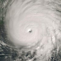
 on Twitter photo A remarkable satellite image - the eye of #typhoon #yagi almost directly over the city of Haikou, with a population of over 3m people, the textbook tropical cyclone symbol, the curved banding almost looks like it's been painted by a brush - just, wow!")