Dale Roberts (@dale_roberts) 's Twitter Profile
Dale Roberts

@dale_roberts

ID: 17529451

calendar_today21-11-2008 02:35:37

110 Tweet

147 Followers

198 Following

The Project (@theprojecttv) 's Twitter Profile Photo

You might not have heard of Aussie mathematician Geordie Williamson but his name is now being uttered in the same breath as great minds like Isaac Newton and Albert Einstein. #TheProjectTV

Geoscience Australia (@geoscienceaus) 's Twitter Profile Photo

Look at how #Canberra has changed in more than thirty years! ⌛ Just a snapshot of what is possible with #DigitalEarthAU. 🛰️ Discover more: bit.ly/2O91Nos #CBR #ACT #80DaysEarth #Landsat #EarthScience #EarthSci #EarthObservation

Geoscience Australia (@geoscienceaus) 's Twitter Profile Photo

We have released cloud free annual NASA Landsat geomedian composites on the TerriaJS NationalMap platform: bit.ly/2RD6lBD (Access the data by clicking on the image and clicking on the S3 link.)

We have released cloud free annual <a href="/NASA_Landsat/">NASA Landsat</a> geomedian composites on the <a href="/TerriaJS/">TerriaJS</a> NationalMap platform: bit.ly/2RD6lBD  (Access the data by clicking on the image and clicking on the S3 link.)
Copernicus EMS (@copernicusems) 's Twitter Profile Photo

After 6+ years of operational experience and several rounds of user consultation we can proudly announce that the main user requirement for #emergency #mapping is removal of clouds 😜

After 6+ years of operational experience and several rounds of user consultation we can proudly announce that the main user requirement for #emergency #mapping is removal of clouds 😜
ANU Media (@anumedia) 's Twitter Profile Photo

Soil study shows Australia at its most stripped back. New research led by #ANUExpert Dale Roberts has produced a much clearer picture of the Australian landscape & how to better manage it under #climatechange. #DigitalEarthAU bit.ly/2RhzIvi

Soil study shows Australia at its most stripped back. New research led by #ANUExpert <a href="/Dale_Roberts/">Dale Roberts</a> has produced a much clearer picture of the Australian landscape &amp; how to better manage it under #climatechange. #DigitalEarthAU bit.ly/2RhzIvi
Geoscience Australia (@geoscienceaus) 's Twitter Profile Photo

We’re celebrating the conclusion of a collaborative project with the ANU to produce a single multispectral image of Australia. This satellite image provides a vividly clear picture of the whole Australian continent right down to the bare soil view. bit.ly/2PgRJaO

We’re celebrating the conclusion of a collaborative project with the ANU to produce a single multispectral image of Australia. This satellite image provides a vividly clear picture of the whole Australian continent right down to the bare soil view. bit.ly/2PgRJaO
NASA Landsat (@nasa_landsat) 's Twitter Profile Photo

Mapping the Mighty Mangrove: A new longitudinal study from Australia has harnessed thirty years of #Landsat data to map the nationwide movement and migration of mangrove forests: landsat.gsfc.nasa.gov/mapping-the-mi…

Mapping the Mighty Mangrove: A new longitudinal study from Australia has harnessed thirty years of #Landsat data to map the nationwide movement and migration of mangrove forests: landsat.gsfc.nasa.gov/mapping-the-mi…
Nature Communications (@naturecomms) 's Twitter Profile Photo

@daleroberts and colleagues from Geoscience Australia used #MachineLearning to make a freely available exposed #soil and #mineral map of the #Australian continent Department of Industry, Science and Resources, ANU Media, NCI Australia, #DigitalEarthAu #WorldSoilDay See the full article here: nature.com/articles/s4146…

Dale Roberts (@dale_roberts) 's Twitter Profile Photo

Mineral and soil map for the continent of #Africa at 10m resolution: pretty results from one of my #machinelearning #algorithms that generates a cloud-free, continental-scale, and consistent #mineral and #soil map. #mineralexploration #satelliteimagery #research.

Mineral and soil map for the continent of #Africa at 10m resolution: pretty results from one of my #machinelearning #algorithms that generates a cloud-free, continental-scale, and consistent #mineral and #soil map. #mineralexploration #satelliteimagery #research.
Dr Robbi Bishop-Taylor 🛰️🌎🌊 (@satellitesci) 's Twitter Profile Photo

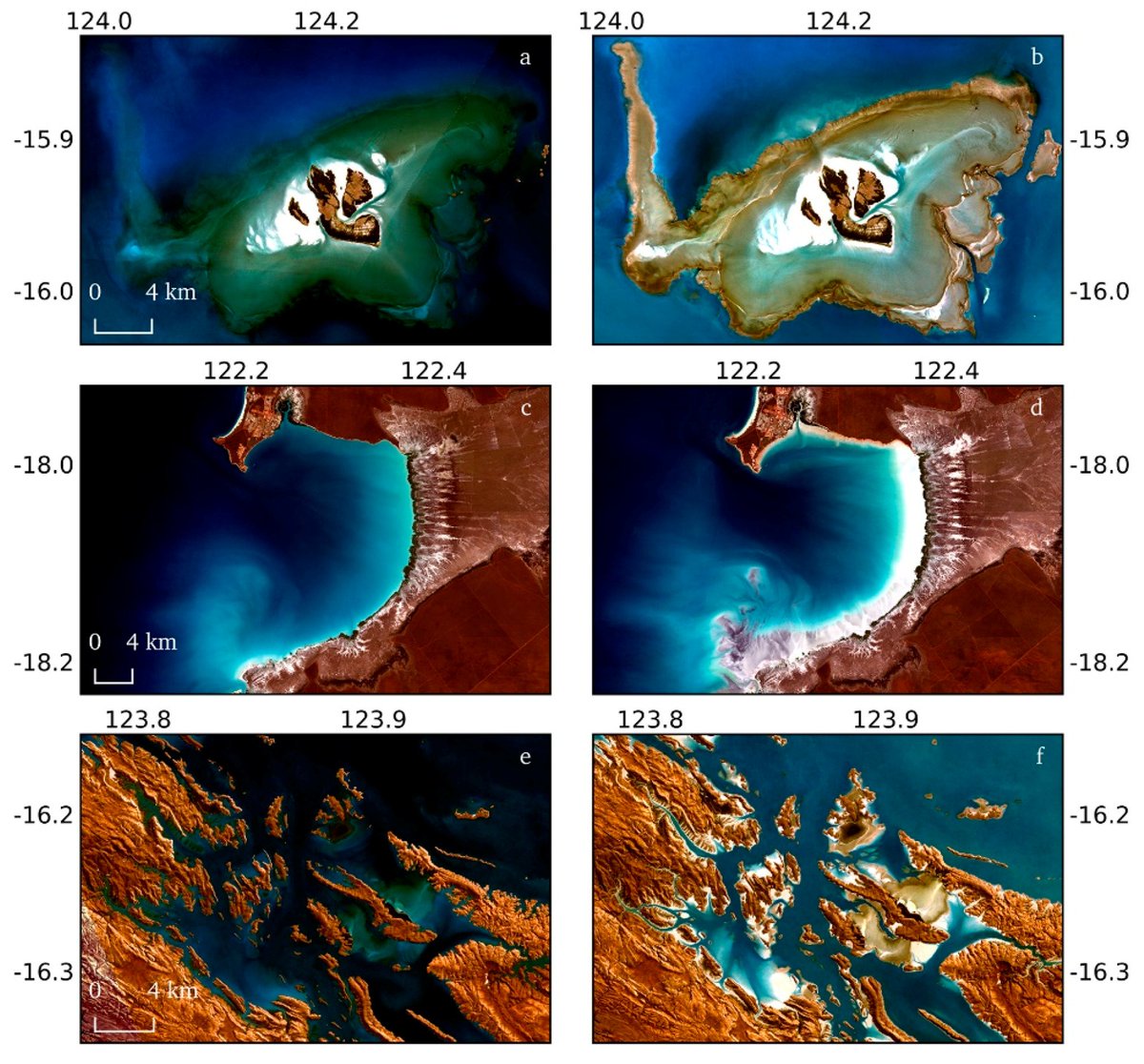
Some super exciting new #OpenAccess research coming out of my Geoscience Australia team: developing continental-scale high & low tide composites using 30 yrs of #Landsat & a multi-res tidal model! And the best thing? The data is online now! #DigitalEarthAU🛰️🌊 nationalmap.gov.au/#share=s-qiKfH…

Some super exciting new #OpenAccess research coming out of my <a href="/GeoscienceAus/">Geoscience Australia</a> team: developing continental-scale high &amp; low tide composites using 30 yrs of #Landsat &amp; a multi-res tidal model! And the best thing? The data is online now! #DigitalEarthAU🛰️🌊
nationalmap.gov.au/#share=s-qiKfH…
Geoscience Australia (@geoscienceaus) 's Twitter Profile Photo

Seamless cloud free composites of #Australia’s intertidal zone at high & low tide using #Landsat #satellite data from 2007-2017. Continental scale model linking tidal height with the date & time of image acquisition. Full article: goo.gl/HHuKhP #RemoteSensing

Seamless cloud free composites of #Australia’s intertidal zone at high &amp; low tide using #Landsat #satellite data from 2007-2017. Continental scale model linking tidal height with the date &amp; time of image acquisition. Full article: goo.gl/HHuKhP #RemoteSensing
Zed Seselja (@zedseselja) 's Twitter Profile Photo

$50 million in Commonwealth funding for the MinEx CRC announced with Senator Matt Canavan today will help with research to boost investment in mining exploration in Australia, creating jobs for the future. minister.industry.gov.au/ministers/cana…

Geoscience Australia (@geoscienceaus) 's Twitter Profile Photo

Dr Andreia Siqueira presented this week at the 2nd Mapping Water Bodies from Space Conference hosted by @ESA, on the benefits of detecting water by using seamless cloud free composite #satellite images created via #EarthObservation time series. goo.gl/e5Hdpz

Dr Andreia Siqueira presented this week at the 2nd Mapping Water Bodies   from Space Conference hosted by @ESA, on the benefits of detecting  water  by using seamless cloud free composite #satellite images created  via  #EarthObservation time series. goo.gl/e5Hdpz