Tristan Meyers (@tristanjmeyers) 's Twitter Profile
Tristan Meyers

@tristanjmeyers

WMO Qualified Meteorologist at National Institute of Water and Atmospheric Research (NIWA) | Data Munger | Data Viz Powered by 🆁 & 🐍 Tweets are my own

ID: 1365816236

calendar_today20-04-2013 01:12:48

774 Tweet

320 Followers

533 Following

Met Office (@metoffice) 's Twitter Profile Photo

Exceptional, if not unprecedented temperatures have been and will continue to affect western Europe in the coming days The heat in Iberia should ease a little, but it will become hotter across much of central Europe and the UK

Met Office (@metoffice) 's Twitter Profile Photo

Here are the highest temperatures across the country today 👇 At least 34 sites have exceeded the UK's previous national record of 38.7°C 🌡️ #heatwave2022 #heatwave

Here are the highest temperatures across the country today 👇 

At least 34 sites have exceeded the UK's previous national record of 38.7°C 🌡️

#heatwave2022 #heatwave
First Up (@firstuprnz) 's Twitter Profile Photo

Ok, what actually is an atmospheric river and why is it brining a month's worth of rain in just a few days? NIWA meteorologist and forecaster Tristan Meyers explains rnz.co.nz/national/progr…

Tristan Meyers (@tristanjmeyers) 's Twitter Profile Photo

Last week's atmospheric river that lead to destructive flooding broke a records here in Aotearoa New Zealand‼️ Using ERA5 Integrated Water Vapour (IVT), we found the highest August values in the NZ region we've seen in data back to 1959.

Ben Noll (@bennollweather) 's Twitter Profile Photo

New Zealand’s August 2022 atmospheric river (AR) was the strongest August AR in the New Zealand region on record, shown by an analysis from Tristan Meyers, Peter Gibson & I. Extreme rainfall in Nelson was a 1-in-120-year event - sorry to those affected! niwa.co.nz/news/exception…

New Zealand’s August 2022 atmospheric river (AR) was the strongest August AR in the New Zealand region on record, shown by an analysis from <a href="/TristanJMeyers/">Tristan Meyers</a>, <a href="/SciGibson/">Peter Gibson</a> &amp; I.

Extreme rainfall in Nelson was a 1-in-120-year event - sorry to those affected!

niwa.co.nz/news/exception…
Ben Noll (@bennollweather) 's Twitter Profile Photo

In New Zealand, we use deep learning to downscale the GEFS 35-day forecast to *5 km resolution* & produce much improved outlooks of rainfall extremes! Excellent work Neelesh Rampal, Peter Gibson, Tristan Meyers & Chris Brandolino. Methodology ⬇️ sciencedirect.com/science/articl…

Tristan Meyers (@tristanjmeyers) 's Twitter Profile Photo

It’s been the wettest day on record for parts of Auckland 😳 Over 260mm has fallen since 9am in some areas with heavy downpours which brought widespread flooding. A state of emergency has been declared.

Tristan Meyers (@tristanjmeyers) 's Twitter Profile Photo

With an atmospheric river landfalling tomorrow, the final monthly totals for Auckland will likely be record-breaking across large swathes of the region.

Tristan Meyers (@tristanjmeyers) 's Twitter Profile Photo

NZ Fire danger spiking this week 🔥 Looks like the worse fire weather we've seen in awhile this week. Gusty winds & temps to the mid-30s; could also be the hottest we've seen in over a year. Extremely dry areas in the South Island are the most at risk. Map: fire danger & winds

NIWA Weather (@niwaweather) 's Twitter Profile Photo

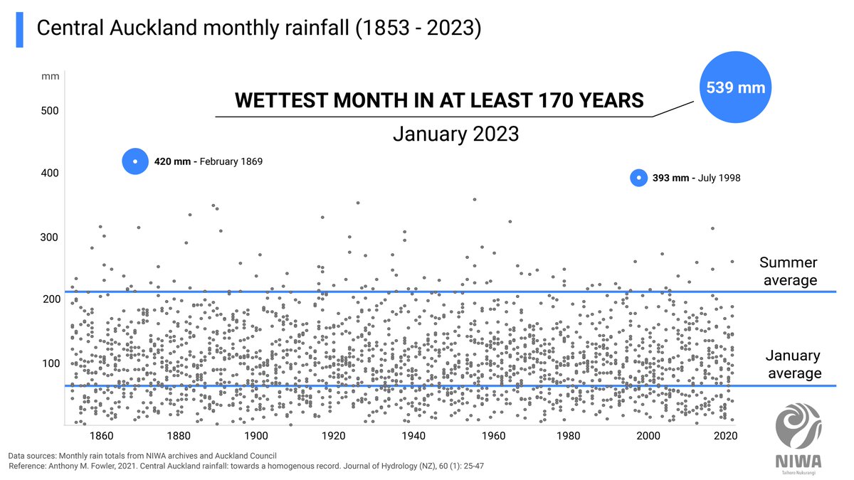
We can confirm that January 2023 was *Auckland's wettest month on record* in at least the last 170 years. Central Auckland had a monthly rainfall total of 539 mm, far exceeding the old record of 420 mm from February 1869. niwa.co.nz/news/auckland-… 🧵 on an unprecedented event...

We can confirm that January 2023 was *Auckland's wettest month on record* in at least the last 170 years.

Central Auckland had a monthly rainfall total of 539 mm, far exceeding the old record of 420 mm from February 1869.

niwa.co.nz/news/auckland-…

🧵 on an unprecedented event...
Tristan Meyers (@tristanjmeyers) 's Twitter Profile Photo

The sun rises on Gabrielle, a system that unleashed over triple the usual February rainfall in less than 24 hours, inundating parts of New Zealand's North Island. The catastrophic flooding left behind will require years of recovery.

Tristan Meyers (@tristanjmeyers) 's Twitter Profile Photo

Hawke's Bay before #CycloneGabrielle ➡️ after Gabrielle. You can see the brown floodwaters swelling lakes and rivers, and plumes of effluent draining into the ocean. The photo on the right is from 18 Feb, several days after the flooding peaked.

Hawke's Bay before #CycloneGabrielle ➡️ after Gabrielle. 

You can see the brown floodwaters swelling lakes and rivers, and plumes of effluent draining into the ocean.

The photo on the right is from 18 Feb, several days after the flooding peaked.
ECMWF (@ecmwf) 's Twitter Profile Photo

🌦️💻 Our latest forecasting system upgrade went live this week. #NewFCSystem Recent webinars included: ✔️The technical changes ✔️Some practical considerations linked to the implementation ✔️Q&As Watch the recordings at the bottom of this #IFS48r1 page➡️ confluence.ecmwf.int/display/FCST/I…

🌦️💻 Our latest forecasting system upgrade went live this week. #NewFCSystem
Recent webinars included:
✔️The technical changes
✔️Some practical considerations linked to the implementation
✔️Q&amp;As
Watch the recordings at the bottom of this #IFS48r1 page➡️ confluence.ecmwf.int/display/FCST/I…
Our Changing World (@rnzscience) 's Twitter Profile Photo

Climate change is making weather forecasting – and predicting extreme events like Hurricane Otis – trickier. "We're in uncharted waters at the moment," says Tristan Meyers NIWA What does this mean for NZ? Listen now! rnz.co.nz/national/progr…

Tristan Meyers (@tristanjmeyers) 's Twitter Profile Photo

I'm proud to be the lead author on the 2023 Annual Climate Summary this year for Aotearoa New Zealand, being published early in January 2024. 2023 will be another one for the record books, in part caused by anthropogenic climate change.

Copernicus ECMWF (@copernicusecmwf) 's Twitter Profile Photo

🌍🌡️2023 is confirmed as the warmest calendar year on record, with a global average temperature of 14.98°C, 0.60°C above the 1991-2020 level, overtaking 2016, the previous warmest year. Learn more in the #C3S Global Climate Highlights report 👉 bit.ly/48Nchyu

NIWA Weather (@niwaweather) 's Twitter Profile Photo

It's official, 2023 was Aotearoa New Zealand’s 2nd-warmest year on record 📈 The country’s three warmest years are 2022, 2023 & 2021. It was a year of weather extremes 🌀 niwa.co.nz/climate/summar… 🧵 on the things you should know about 2023’s climate in New Zealand

It's official, 2023 was Aotearoa New Zealand’s 2nd-warmest year on record 📈

The country’s three warmest years are 2022, 2023 &amp; 2021.

It was a year of weather extremes 🌀

niwa.co.nz/climate/summar…

🧵 on the things you should know about 2023’s climate in New Zealand