Greg Carbin ☮️ (@gcarbin) 's Twitter Profile
Greg Carbin ☮️

@gcarbin

Tweets & retweets, mostly about weather. Follow @NWSSPC if you want the real deal on severe weather. Meteorology is mind-bending. That's why I like it.

ID: 824191926

calendar_today14-09-2012 23:43:11

7,7K Tweet

8,8K Followers

2,2K Following

Nick P Bassill (@nickpbassill) 's Twitter Profile Photo

The NYS Mesonet at UAlbany's Stony Brook site has now broken the entire network's all-time records for 1, 3, and 24 hour rainfall set previously during Ida. Now (previous): 1H: 3.79" (3.76) 3H: ~7" * (5.57") 24H 9.38" * (8.44") *Not final - may increase. #nywx #nycwx #stonybrook

The <a href="/nysmesonet/">NYS Mesonet at UAlbany</a>'s Stony Brook site has now broken the entire network's all-time records for 1, 3, and 24 hour rainfall set previously during Ida.

Now (previous):

1H: 3.79" (3.76)
3H: ~7" * (5.57")
24H 9.38" * (8.44")

*Not final - may increase. #nywx #nycwx #stonybrook
Collin Gross (@collingrosswx) 's Twitter Profile Photo

2 areas of extreme rainfall over the last 24 hours in southwest Connecticut and Long Island. Both areas received 6-12+ inches! This caused catastrophic flooding and prompted Flash Flood Emergencies to be issued. The MRMS recurrence interval is greater than 200 years! #CTwx #NYwx

2 areas of extreme rainfall over the last 24 hours in southwest Connecticut and Long Island. Both areas received 6-12+ inches! This caused catastrophic flooding and prompted Flash Flood Emergencies to be issued. The MRMS recurrence interval is greater than 200 years! #CTwx #NYwx
Andrew Loconto (@andrewloconto) 's Twitter Profile Photo

At 115 PM Sunday, the gage on the Housatonic River at Stevenson, CT was at baseflow levels (~582 cfs). By 6:15, after at least 10" of rain fell, level would rise 91-fold (53300 cfs!). In context, that flow is ~5 times the typical flow on the much larger CT River at Montague, MA.

At 115 PM Sunday, the gage on the Housatonic River at Stevenson, CT was at baseflow levels (~582 cfs).  By 6:15, after at least 10" of rain fell, level would rise 91-fold (53300 cfs!). In context, that flow is ~5 times the typical flow on the much larger CT River at Montague, MA.
Oklahoma Mesonet (@okmesonet) 's Twitter Profile Photo

🎉 Oklahoma Mesonet 30th Anniversary post for August! 🎉 On this date 17 years ago, one of the craziest #okwx events occurred when Tropical Storm Erin re-intensified over Oklahoma producing major flooding and peak wind gusts of 75 mph. #okmesonet

🎉 Oklahoma Mesonet 30th Anniversary post for August! 🎉

On this date 17 years ago, one of the craziest #okwx events occurred when Tropical Storm Erin re-intensified over Oklahoma producing major flooding and peak wind gusts of 75 mph. #okmesonet
Greg Carbin ☮️ (@gcarbin) 's Twitter Profile Photo

What a crazy 24 hours from western #CTwx to Long Island #NYwx! Here is the estimated hourly rainfall accumulation loop for the 24 hours ending at 8 am EDT, Aug. 19, 2024.

Greg Carbin ☮️ (@gcarbin) 's Twitter Profile Photo

Two Images from #Vermont today: 1) Morning moisture rising from verdant forests into the clouds. 2) Subsequent moisture-laden clouds unleashing 1-2-inch per hour rainfall rates during the late afternoon. Close lightning, no rainbow, minor road washouts, happy gardens. #VTwx

Two Images from #Vermont today: 1) Morning moisture rising from verdant forests into the clouds. 2) Subsequent moisture-laden clouds unleashing 1-2-inch per hour rainfall rates during the late afternoon. Close lightning, no rainbow, minor road washouts, happy gardens. #VTwx
Alex Boreham (@cyclonicwx) 's Twitter Profile Photo

Here's something you don't see too often - the center of a hurricane on radar from eastern Newfoundland! #Ernesto is certainly in an unusual spot to still be a TC. Lack of nearby trough to blame. Can see from the radar how its southwest side is mostly eroded too, cooler water

Doug Lewin (@douglewinenergy) 's Twitter Profile Photo

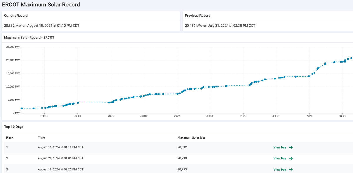
Top 3 solar days in ERCOT's history are today and the previous two days. Solar is consistently producing ~25% of our power needs on the hottest summer days with the highest demand. #energytwitter #txlege #txenergy

Top 3 solar days in ERCOT's history are today and the previous two days. Solar is consistently producing ~25% of our power needs on the hottest summer days with the highest demand. #energytwitter #txlege #txenergy
Jared Rennie (@jjrennie) 's Twitter Profile Photo

Here's the MRMS derived 24-hr ARI exceedances from the rainfall that affected parts of SW Connecticut and Long Island. Jacob Feuerstein #CTwx #NYwx #StateOfFlood

Here's the MRMS derived 24-hr ARI exceedances from the rainfall that affected parts of SW Connecticut and Long Island. 

<a href="/Jacob_Feuer/">Jacob Feuerstein</a> #CTwx #NYwx #StateOfFlood
NWS Amarillo (@nwsamarillo) 's Twitter Profile Photo

Today was officially the hottest August day EVER in Amarillo!🔥 Amarillo🌡️: 108°F (Breaks monthly record high of 107°F & daily record high of 101°F) Borger🌡️: 109°F (Breaks daily record high of 102°F set in 2011) #phwx #txwx Here's our live reaction to this information:

NWS Weather Prediction Center (@nwswpc) 's Twitter Profile Photo

Dangerous, record-breaking #heat continues through Saturday for the Southern Plains before gradually waning and shifting northward into the Central Plains and Midwest later this weekend. Be sure to follow proper heat safety and check in on vulnerable individuals.

Dangerous, record-breaking #heat continues through Saturday for the Southern Plains before gradually waning and shifting northward into the Central Plains and Midwest later this weekend. Be sure to follow proper heat safety and check in on vulnerable individuals.
Greg Carbin ☮️ (@gcarbin) 's Twitter Profile Photo

Had a good friend who used to call these days, “One of the ten best days of the millennium!”. On the Connecticut River, north of Wilder, #VTwx today. Also, #NHwx on the right bank.

Had a good friend who used to call these days, “One of the ten best days of the millennium!”. On the Connecticut River, north of Wilder, #VTwx today. Also, #NHwx on the right bank.
Dr. Alicia M Bentley (@aliciambentley) 's Twitter Profile Photo

A friendly reminder that the NAM Nest (NAM 3km) does *not* turn off latent heat fluxes when the lowest model level has RH values ≥ 95%. This can result in unrealistically strong tropical cyclones (e.g., 865-mb TC Barry in 2019). Don't use the NAM Nest for TC intensity! #Francine

Collin Gross (@collingrosswx) 's Twitter Profile Photo

TERRIFYING footage from a live cam in the path of the #BridgeFire in Southern California. On Mount High’s East Summit. Monster flames and even some quick firenado spin ups! #CAwx

Greg Carbin ☮️ (@gcarbin) 's Twitter Profile Photo

A look at the estimated accumulating rainfall for the 24 hours ending 7 am CDT, Sep. 12, 2024 from #HurricaneFrancine. #LAwx