Dr. Kim Wood (@drkimwood) 's Twitter Profile
Dr. Kim Wood

@drkimwood

Nonbinary associate professor (they/them) studying hurricanes at @UArizona. Open science, Python, scicomm, feline 🐈 enthusiast. Personal account.

ID: 3242553150

linkhttps://kouya.has.arizona.edu calendar_today11-06-2015 19:27:59

10,10K Tweet

6,6K Takipçi

391 Takip Edilen

Dr. Kim Wood (@drkimwood) 's Twitter Profile Photo

Hurricane Francine has been producing deep convection (shown by cold cloud tops) near its center the past few hours, indicating a more organized core, captured by 1-minute GOES-East meso sector imagery.

Dr. Kim Wood (@drkimwood) 's Twitter Profile Photo

I thoroughly enjoyed my first visit to the National Weather Center and the School of Meteorology! Thanks again for hosting me, and I hope I can return soon.

I thoroughly enjoyed my first visit to the National Weather Center and the School of Meteorology! Thanks again for hosting me, and I hope I can return soon.
Dr. Kim Wood (@drkimwood) 's Twitter Profile Photo

Watch a burst of deep convection near Francine's center generate a ripple effect in cloud-top temperatures as shown by 1-minute GOES-East infrared (Band 13) images. The hurricane has strengthened overnight and may continue to do so until shear + dry air increase near the coast.

Brandon Yoshizawa (@bay_photography) 's Twitter Profile Photo

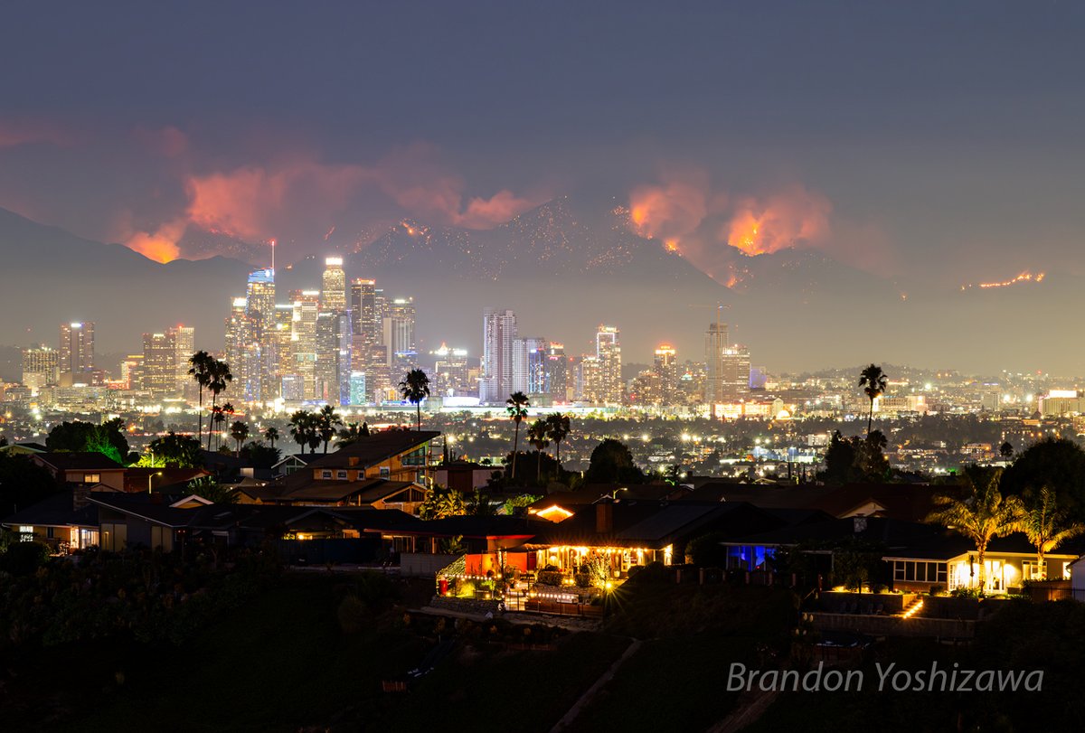
Photo taken 9/10/24 The Bridge Fire in the Angeles National Forest exploded to ~47k acres with 0% containment. The fire was quite visible last night from behind the Los Angeles skyline photographed the Baldwin Hills area. A sad reality of fire season in LA.

Photo taken 9/10/24

The Bridge Fire in the Angeles National Forest exploded to ~47k acres with 0% containment.

The fire was quite visible last night from behind the Los Angeles skyline photographed the Baldwin Hills area.

A sad reality of fire season in LA.
Michael Lowry (@michaelrlowry) 's Twitter Profile Photo

As Alex Boreham and Deelan Jariwala noted, some vigorous convection recently rotating upshear in Francine. Notice the inner core lightning associated with this upshear convection as well. May be a last gasp, but studies have found upshear lightning more common in strengthening storms.

Dr. Kim Wood (@drkimwood) 's Twitter Profile Photo

If you've seen comments about deep convection recently rotating upshear in Francine, this geometry is what they're referencing. (Think "downshear" like "downwind.") Black arrow = shear direction. Blue arrow = direction of convection rotating upshear. Product courtesy of CIMSS.

If you've seen comments about deep convection recently rotating upshear in Francine, this geometry is what they're referencing. (Think "downshear" like "downwind.")

Black arrow = shear direction.
Blue arrow = direction of convection rotating upshear.
Product courtesy of CIMSS.
Charles Peek (@charlespeekwx) 's Twitter Profile Photo

Northern eyewall of Cat. 2 #Hurricane #Francine impacting Morgan City, LA now. Live coverage on The The Weather Channel continues with myself and Jim Cantore in Morgan City and other teams spread across the area.


Dr. Kim Wood (@drkimwood) 's Twitter Profile Photo

Francine makes me want to focus on research SO badly, yet I have a million other things on my plate that I need to tackle instead (someone please help me say no more often).

National Hurricane Center (@nhc_atlantic) 's Twitter Profile Photo

5pm CDT Sep 11th -- #Francine has made landfall in southern Louisiana in the Parish of Terrebonne, about 30 miles south-southwest of Morgan City, as a Category 2 hurricane. Maximum sustained winds are estimated to be near 100 mph (155 km/h). TCU: hurricanes.gov/#Francine

5pm CDT Sep 11th -- #Francine has made landfall in southern Louisiana in the Parish of Terrebonne, about 30 miles south-southwest of Morgan City, as a Category 2 hurricane.  

Maximum sustained winds are estimated to be near 100 mph (155 km/h).

TCU: hurricanes.gov/#Francine
Dr. Kim Wood (@drkimwood) 's Twitter Profile Photo

Evolution of Francine today from sunrise through landfall in southern Louisiana. Estimated (over water) intensity at landfall was 100 mph, which is a category 2 hurricane on the Saffir-Simpson hurricane wind scale.

Dr. Kim Wood (@drkimwood) 's Twitter Profile Photo

I would like to thank my past self for documenting the steps needed for maintaining SSL certificates because THEY WORKED. (If you recently encountered a browser warning when accessing my webpage, that should be gone now!)

Greg Carbin ☮️ (@gcarbin) 's Twitter Profile Photo

A look at the estimated accumulating rainfall for the 24 hours ending 7 am CDT, Sep. 12, 2024 from #HurricaneFrancine. #LAwx

NHC Eastern Pacific (@nhc_pacific) 's Twitter Profile Photo

The NHC Public Advisory, Tropical Cyclone Discussion, including Key Messages on Tropical Depression Nine-E are also available in Spanish at hurricanes.gov. A graphic showing rainfall potential is also available at: nhc.noaa.gov/refresh/graphi…

The NHC Public Advisory, Tropical Cyclone Discussion, including Key Messages on Tropical Depression Nine-E are also available in Spanish at hurricanes.gov.  A graphic showing rainfall potential is also available at: 
nhc.noaa.gov/refresh/graphi…
Dr. Mathew Barlow (@mathewabarlow) 's Twitter Profile Photo

Comparing current vegetation over Africa with a year ago ... Recent unusual rain over the southern Sahara Desert has resulted in a noticeable change in greenery.

AMS Weather Band (@amswxband) 's Twitter Profile Photo

We're teaming up with Girls Who Chase for an exciting webinar on meteorology ⛅ and storm chasing 🌪️! Join us for an engaging discussion with weather experts and veteran storm chasers Ginger Zee, Elizabeth Leitman, karen kosiba, & Melanie Metz. Register today: bit.ly/4eeKJ7S

We're teaming up with <a href="/GirlsWhoChase/">Girls Who Chase</a> for an exciting webinar on meteorology ⛅ and storm chasing 🌪️!

Join us for an engaging discussion with weather experts and veteran storm chasers <a href="/Ginger_Zee/">Ginger Zee</a>, <a href="/WxLiz/">Elizabeth Leitman</a>, <a href="/karen_kosiba/">karen kosiba</a>, &amp; <a href="/MetzStormMedia/">Melanie Metz</a>.

Register today: bit.ly/4eeKJ7S