NASA Earth (@nasaearth) 's Twitter Profile
NASA Earth

@nasaearth

NASA’s favorite (habitable) planet. 🌎💚 Studying Earth from ground to orbit. Verification: nasa.gov/socialmedia

ID: 24919888

linkhttps://science.nasa.gov/earth/ calendar_today17-03-2009 17:45:41

23,23K Tweet

3,7M Followers

101 Following
NASA JPL (@nasajpl) 's Twitter Profile Photo

Autonomous underwater robots helping to better predict global sea level rise? Meet IceNode! 🧊 This project could one day help scientists calculate the melt rate of Antarctic ice shelves, gathering data in one of the most inaccessible places on Earth. go.nasa.gov/474JINs

Autonomous underwater robots helping to better predict global sea level rise? Meet IceNode! 🧊

This project could one day help scientists calculate the melt rate of Antarctic ice shelves, gathering data in one of the most inaccessible places on Earth. go.nasa.gov/474JINs
NASA (@nasa) 's Twitter Profile Photo

Can you see our name in these satellite photos of Earth? Spell yours in images from the NASA Earth & USGS Landsat program, which has observed our home planet for over 50 years: go.nasa.gov/EarthName

Can you see our name in these satellite photos of Earth?
 
Spell yours in images from the <a href="/NASAEarth/">NASA Earth</a> &amp; <a href="/USGS/">USGS</a> Landsat program, which has observed our home planet for over 50 years: go.nasa.gov/EarthName
NASA Earth (@nasaearth) 's Twitter Profile Photo

Typhoon Shanshan made landfall in Japan. The NOAA-20 satellite captured these images of the powerful storm as it approached the main islands on Aug. 28 (left) and about five hours after making landfall on Aug. 29 (right) as it moved over Kyushu. go.nasa.gov/3Xpjimw

Typhoon Shanshan made landfall in Japan. The <a href="/NOAA/">NOAA</a>-20 satellite captured these images of the powerful storm as it approached the main islands on Aug. 28 (left) and about five hours after making landfall on Aug. 29 (right) as it moved over Kyushu. go.nasa.gov/3Xpjimw
International Space Station (@space_station) 's Twitter Profile Photo

East of the Southern Alps lies a trio of lakes that run near-parallel to one another: Lakes Tekapo, Pukaki and Ohau. Images were taken by NASA astronaut Matthew Dominick as the space station orbited 265 miles above New Zealand. More of #EarthFromSpace: flic.kr/s/aHsmACYoYM

East of the Southern Alps lies a trio of lakes that run near-parallel to one another: Lakes Tekapo, Pukaki and Ohau.

Images were taken by NASA astronaut <a href="/dominickmatthew/">Matthew Dominick</a> as the space station orbited 265 miles above New Zealand. 

More of #EarthFromSpace: flic.kr/s/aHsmACYoYM
NASA Earth (@nasaearth) 's Twitter Profile Photo

Egypt is relocating its capital to a brand new city in the desert outside of Cario. #Landsat captured these images of the new capital in August 2017 and 2024, showing the expansion of the city and several prominent landmarks. go.nasa.gov/3yOHjdg

NASA JPL (@nasajpl) 's Twitter Profile Photo

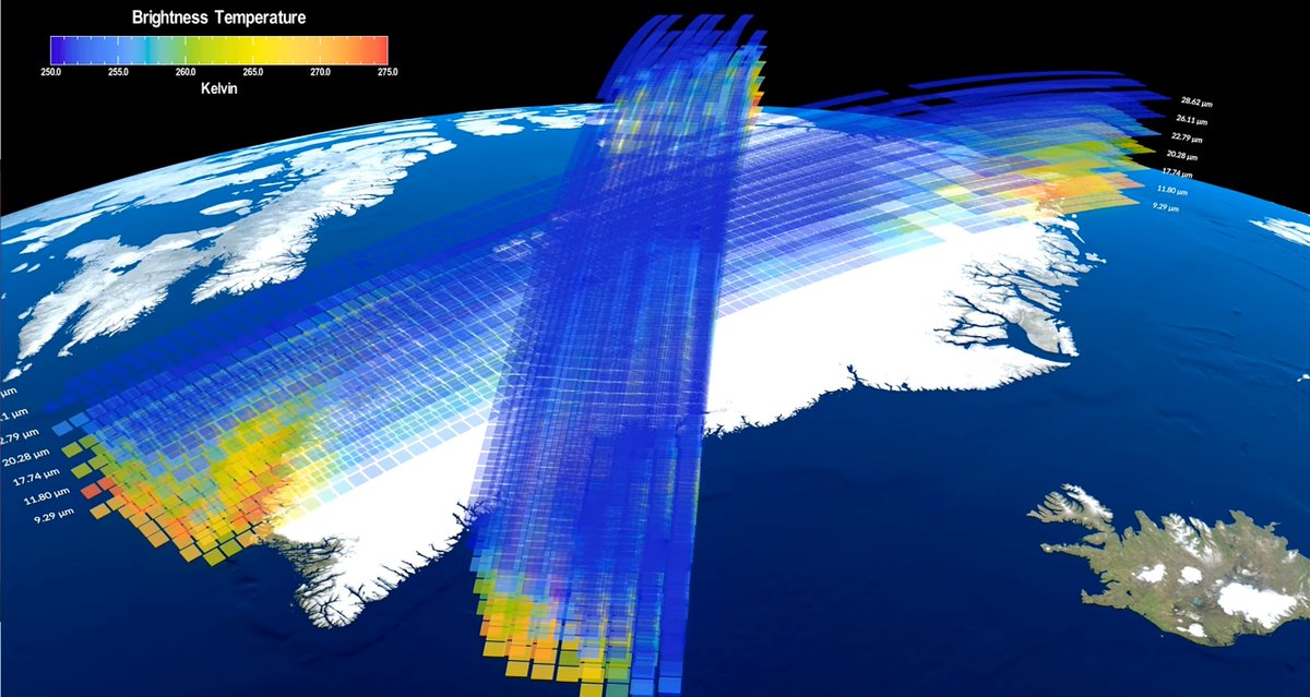
X marks the spot 🌎 PREFIRE, NASA's mission to study Earth's poles, has started sending back data! Expanded vertically, this data from several orbits over Greenland shows how infrared heat emissions vary through the atmosphere: NASA.GOV

X marks the spot 🌎

PREFIRE, <a href="/NASA/">NASA</a>'s mission to study Earth's poles, has started sending back data!

Expanded vertically, this data from several orbits over Greenland shows how infrared heat emissions vary through the atmosphere: NASA.GOV
NASA Earth (@nasaearth) 's Twitter Profile Photo

Wildland fires are scorching Idaho. Together, the Wapiti fire and Middle Fork Complex fires have charred tens of thousands of acres. The USGS NASA Landsat 8 satellite captured this image of smoke and active fire on August 31. go.nasa.gov/3TeCAZf

Wildland fires are scorching Idaho. Together, the Wapiti fire and Middle Fork Complex fires have charred tens of thousands of acres. The <a href="/USGS/">USGS</a> <a href="/NASA_Landsat/">NASA Landsat</a> 8 satellite captured this image of smoke and active fire on August 31. go.nasa.gov/3TeCAZf
NASA (@nasa) 's Twitter Profile Photo

NASA and @ESA’s near-Earth object study teams predict that a very small (~1 meter) #asteroid will harmlessly impact Earth’s atmosphere in a few hours at ~12:40pm EDT (~16:40 UTC) and create a fireball off the east coast of the northern Philippines.

NASA and @ESA’s near-Earth object study teams predict that a very small (~1 meter) #asteroid will harmlessly impact Earth’s atmosphere in a few hours at ~12:40pm EDT (~16:40 UTC) and create a fireball off the east coast of the northern Philippines.
NASA Goddard (@nasagoddard) 's Twitter Profile Photo

Feeling so fly like an...ARCSIX? Over several weeks this summer, NASA researchers and agency-funded partners with the ARCSIX mission flew planes over northern Greenland to study how clouds affect the way sea ice behaves during the summer melt season. go.nasa.gov/3MuDop2

Feeling so fly like an...ARCSIX? 

Over several weeks this summer, NASA researchers and agency-funded partners with the ARCSIX mission flew planes over northern Greenland to study how clouds affect the way sea ice behaves during the summer melt season.
go.nasa.gov/3MuDop2
NASA Earth (@nasaearth) 's Twitter Profile Photo

Flash flooding inundated villages, swamped farmland, and damaged infrastructure in Sudan. @nasa’s Terra & Aqua satellites captured these enhanced-color images showing floodwater (dark blue) along the Nile and Atbarah rivers before and after the rains. go.nasa.gov/4dQ9jMM

Flash flooding inundated villages, swamped farmland, and damaged infrastructure in Sudan. 

@nasa’s Terra &amp; Aqua satellites captured these enhanced-color images showing floodwater (dark blue) along the Nile and Atbarah rivers before and after the rains. go.nasa.gov/4dQ9jMM
NASA Ames (@nasaames) 's Twitter Profile Photo

Shining, shimmering, tumbling Our Solar Sail is currently orbiting Earth, slowly tumbling as expected while the team characterizes its boom and sails. You can #SpotTheSail intermittently as it passes overhead using our tool in the #NASA_App. Learn more: go.nasa.gov/3zahIvj

Shining, shimmering, tumbling

Our Solar Sail is currently orbiting Earth, slowly tumbling as expected while the team characterizes its boom and sails. You can #SpotTheSail intermittently as it passes overhead using our tool in the #NASA_App. Learn more: go.nasa.gov/3zahIvj
NASA Earth (@nasaearth) 's Twitter Profile Photo

Puerto Rico is home to 1,300+ square miles of coral reefs. But corals are struggling as ocean temperatures rise. As part of the @nasa_es bilingual OCEANOS program, thirty Puerto Rican students conducted fieldwork in June to monitor & conserve reefs. go.nasa.gov/3X6XN8o