NWS Bay Area πŸŒ‰ (@nwsbayarea) 's Twitter Profile
NWS Bay Area πŸŒ‰

@nwsbayarea

Official Twitter account for the National Weather Service San Francisco Bay Area. Details: weather.gov/twitter

ID: 596687292

linkhttps://www.weather.gov/NWSBayArea/ calendar_today01-06-2012 16:34:16

59,59K Tweet

190,190K Followers

640 Following

NWS Bay Area πŸŒ‰ (@nwsbayarea) 's Twitter Profile Photo

Wow! That is an impressive smoke low pushing across ID! Meanwhile, we have clear skies across the majority of the state, with the marine layer returning to the immediate coast from Half Moon Bay and areas southward. #CAwx

NWS Bay Area πŸŒ‰ (@nwsbayarea) 's Twitter Profile Photo

Look at this...about 15-20° warmer than the same time yesterday🌑️ around the #BayArea. WOW!!! 24 Hour Temp Change for the Weather in Context Win. Many areas will be even warmer tomorrow. #cawx

Look at this...about 15-20° warmer than the same time yesterday🌑️ around the #BayArea. WOW!!!
24 Hour Temp Change for the Weather in Context Win.

Many areas will be even warmer tomorrow.

#cawx
CAL FIRE LNU (@calfirelnu) 's Twitter Profile Photo

Through Labor Day, our Unit has seen 285 wildfires burn 23,994 acres. Remember, eight of the 10 largest wildfires our Unit has seen were started in the months of August, September and October. πŸ”₯ Stay vigilant and take extra precautions. One Less Spark means One Less Wildfire.

Through Labor Day, our Unit has seen 285 wildfires burn 23,994 acres.

Remember, eight of the 10 largest wildfires our Unit has seen were started in the months of August, September and October.

πŸ”₯ Stay vigilant and take extra precautions. One Less Spark means One Less Wildfire.
NWS Bay Area πŸŒ‰ (@nwsbayarea) 's Twitter Profile Photo

While temperatures are not forecast to be quite like some of our Labor Day week heat waves, it'll still be 5 to 15 degrees above normal for parts of the area. Be sure to abide by your heat safety protocols! In addition, there will be a fire weather threat with the heat! #Cawx

While temperatures are not forecast to be quite like some of our Labor Day week heat waves, it'll still be 5 to 15 degrees above normal for parts of the area. Be sure to abide by your heat safety protocols! In addition, there will be a fire weather threat with the heat! #Cawx
NWS Bay Area πŸŒ‰ (@nwsbayarea) 's Twitter Profile Photo

The "Unofficial end to Summer" was yesterday, but today's maximum temperature map says otherwise. Interior locations with little to no marine layer influence were 100Β°F+. #cawx

The "Unofficial end to Summer" was yesterday, but today's maximum temperature map says otherwise. Interior locations with little to no marine layer influence were 100Β°F+.  #cawx
NWS Bay Area πŸŒ‰ (@nwsbayarea) 's Twitter Profile Photo

Moderate HeatRisk and near critical fire weather conditions will continue through at least tomorrow. Follow these safety tips to keep yourself and others safe. #CAwx

Moderate HeatRisk and near critical fire weather conditions will continue through at least tomorrow. Follow these safety tips to keep yourself and others safe. #CAwx
NOAA Space Weather Prediction Center (@nwsswpc) 's Twitter Profile Photo

WARNING: Geomagnetic K-index of 5 expected Valid From: 2024 Sep 04 1043 UTC Valid To: 2024 Sep 04 1800 UTC Warning Condition: Onset NOAA Scale: G1 - Minor Issue Time: 2024 Sep 04 1043 UTC bit.ly/3wVgAKH

NWS Bay Area πŸŒ‰ (@nwsbayarea) 's Twitter Profile Photo

We're seeing patchy fog develop with visibility as low as 1/2mi early this morning from approximately Santa Cruz south to Salinas and Monterey. Be careful on your morning commute and remember these tips when you encounter fog. #calwx

We're seeing patchy fog develop with visibility as low as 1/2mi early this morning from approximately Santa Cruz south to Salinas and Monterey. Be careful on your morning commute and remember these tips when you encounter fog. #calwx
NWS Bay Area πŸŒ‰ (@nwsbayarea) 's Twitter Profile Photo

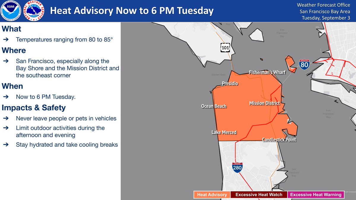
Due to onshore flow across the city of San Francisco, temperatures in the city are running below the earlier forecast, and are no longer expected to reach advisory levels. Thus, the Heat Advisory is cancelled ONLY for the city of San Francisco. #CAwx

NWS Bay Area πŸŒ‰ (@nwsbayarea) 's Twitter Profile Photo

Heat Advisory continues through 11 PM Thursday for the interior Bay Area and Central Coast. Never leave children or pets in unattended vehicles! Limit time outdoors during the afternoon and evening, stay hydrated, and take cooling breaks. #CAwx

Heat Advisory continues through 11 PM Thursday for the interior Bay Area and Central Coast. Never leave children or pets in unattended vehicles! Limit time outdoors during the afternoon and evening, stay hydrated, and take cooling breaks. #CAwx
NWS Bay Area πŸŒ‰ (@nwsbayarea) 's Twitter Profile Photo

The Heat Advisory has been extended through 8 PM Friday. Never leave people or pets in vehicles, limit outdoor activities during the afternoon and evening, stay hydrated and take cooling breaks. #CAwx

The Heat Advisory has been extended through 8 PM Friday. Never leave people or pets in vehicles, limit outdoor activities during the afternoon and evening, stay hydrated and take cooling breaks. #CAwx
NWS Bay Area πŸŒ‰ (@nwsbayarea) 's Twitter Profile Photo

⚠️Fire conditions remain dangerous across the interior through Friday, as hot and dry conditions continue. Don't cause the spark that sets off a wildfire! #CAwx

⚠️Fire conditions remain dangerous across the interior through Friday, as hot and dry conditions continue. Don't cause the spark that sets off a wildfire! #CAwx
NWS Los Angeles (@nwslosangeles) 's Twitter Profile Photo

#RedFlagWarning now in effect for southern #SantaBarbara County and most mountains thru Sat. The environment is ripe for any new fires to grow fast and behave erratically. Avoid using anything that can spark a fire. Be SET to evacuate if you live in a high fire risk area. #cawx

#RedFlagWarning now in effect for southern #SantaBarbara County and most mountains thru Sat. The environment is ripe for any new fires to grow fast and behave erratically. Avoid using anything that can spark a fire. Be SET to evacuate if you live in a high fire risk area. #cawx
NWS Bay Area πŸŒ‰ (@nwsbayarea) 's Twitter Profile Photo

🌑️Hot temperatures continue inland with a Heat Advisory through Friday night. Moderate risk for heat-related illnesses continues, especially for vulnerable populations. #CAwx

🌑️Hot temperatures continue inland with a Heat Advisory through Friday night. Moderate risk for heat-related illnesses continues, especially for vulnerable populations. #CAwx
NWS Bay Area πŸŒ‰ (@nwsbayarea) 's Twitter Profile Photo

The Heat Advisory remains in effect until 8 PM this evening for inland areas. Never leave people or pets in vehicles, limit outdoor activities during the afternoon and evening, stay hydrated and take cooling breaks. #CAwx #BayAreaWX

The Heat Advisory remains in effect until 8 PM this evening for inland areas. Never leave people or pets in vehicles, limit outdoor activities during the afternoon and evening, stay hydrated and take cooling breaks. #CAwx #BayAreaWX
NWS Bay Area πŸŒ‰ (@nwsbayarea) 's Twitter Profile Photo

Near Critical Fire Weather conditions exist across the Bay Area and Central Coast today given low relative humidity, hot daytime temperatures, and breezy winds. Here are a few "don'ts", so you can help prevent new wildfire starts. #cawx

Near Critical Fire Weather conditions exist across the Bay Area and Central Coast today given low relative humidity, hot daytime temperatures, and breezy winds.  Here are a few "don'ts", so you can help prevent new wildfire starts. #cawx