Sydney Madison (@sydneymadisonw) 's Twitter Profile
Sydney Madison

@sydneymadisonw

Good Morning Carolinas Meteorologist @wpdeabc15 // Arizona State University alumna // “Well damn, Jackie, I can't control the weather" // Always hungry 🤤

ID: 1189670945633423360

linkhttps://wpde.com/station/people/sydney-madison calendar_today30-10-2019 22:30:38

2,2K Tweet

1,1K Followers

313 Following

Scotty Powell (@scottypowellwx) 's Twitter Profile Photo

These folks right here are not competitors, they are truly friends. We all have the love of weather and a servants heart to make sure you and your family and friends are prepared and informed when the worst of the worst happens. Hopefully we all can get back together soon! ❤️❤️

These folks right here are not competitors, they are truly friends. We all have the love of weather and a servants heart to make sure you and your family and friends are prepared  and informed when the worst of the worst happens. Hopefully we all can get back together soon! ❤️❤️
Ed Piotrowski (@edpiotrowski) 's Twitter Profile Photo

It's increasingly likely we'll be impacted by a significant Nor'easter on Sunday. The strength and track of the system are still uncertain but based on the current data, here's what we're looking at for Sunday. RAIN - Heavy rain is likely with several inches possible. Minor

It's increasingly likely we'll be impacted by a significant Nor'easter on Sunday.  The strength and track of the system are still uncertain but based on the current data, here's what we're looking at for Sunday.

RAIN - Heavy rain is likely with several inches possible. Minor
Ed Piotrowski (@edpiotrowski) 's Twitter Profile Photo

Lucky to get to join this amazing morning team today as we get you through what’s likely going to be a high impact storm with strong wind and a tornado risk. Join us on ABC-15 right now! Simon Williams Camille J Gayle Sydney Madison

Lucky to get to join this amazing morning team today as we get you through what’s likely going to be a high impact storm with strong wind and a tornado risk. Join us on ABC-15 right now! <a href="/SimonWPDE/">Simon Williams</a> <a href="/CamilleGayle_tv/">Camille J Gayle</a> <a href="/SydneyMadisonW/">Sydney Madison</a>
Ed Piotrowski (@edpiotrowski) 's Twitter Profile Photo

TUESDAY 8 AM UPDATE ON TODAY'S INTENSE STORM It's relatively quiet right now but things will go downhill through the day with very high wind and the potential for a strong tornado. PLEASE make sure you stay weather aware and have multiple ways to get warnings if any are issued.

TUESDAY 8 AM UPDATE ON TODAY'S INTENSE STORM

It's relatively quiet right now but things will go downhill through the day with very high wind and the potential for a strong tornado. PLEASE make sure you stay weather aware and have multiple ways to get warnings if any are issued.
NWS Wilmington, NC (@nwswilmingtonnc) 's Twitter Profile Photo

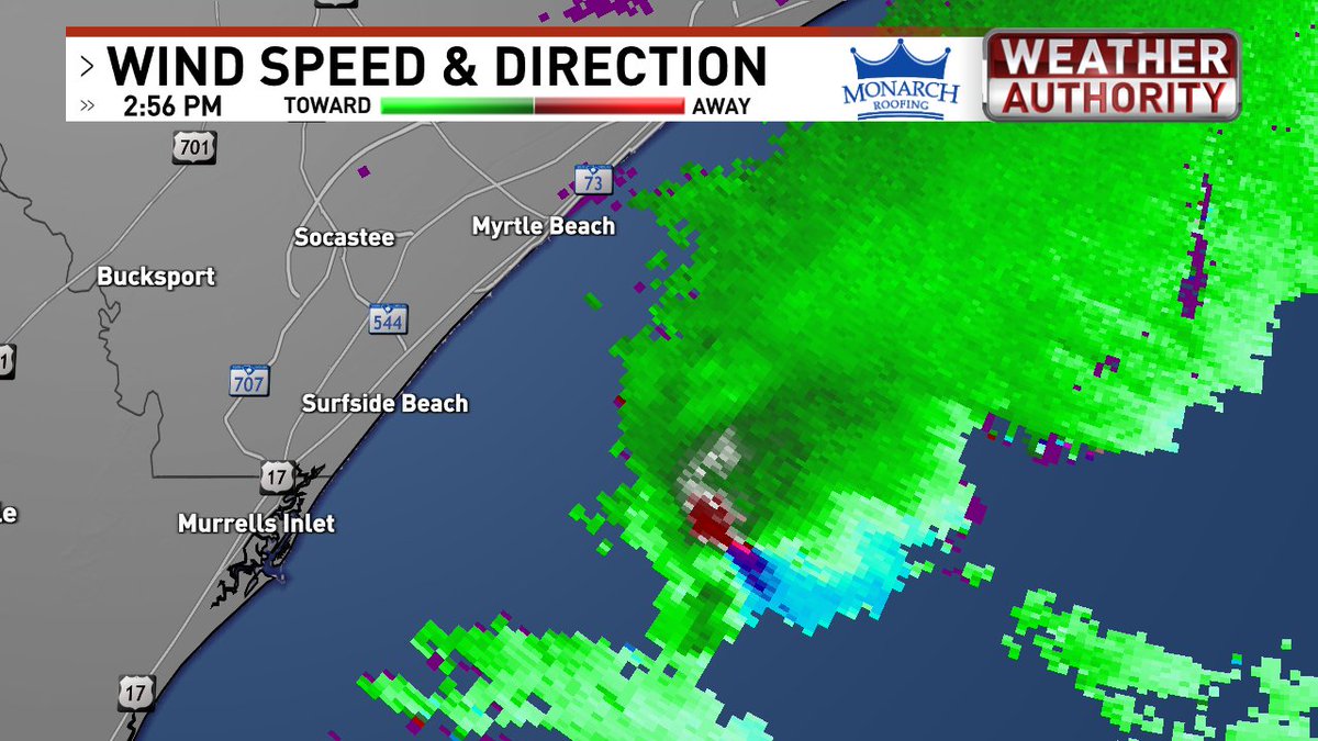
We are monitoring an intense supercell offshore of Myrtle Beach making a run at the North Myrtle Beach area in the next 20 mins or so. Be ready to seek shelter if a Tornado Warning issued!

We are monitoring an intense supercell offshore of Myrtle Beach making a run at the North Myrtle Beach area in the next 20 mins or so. Be ready to seek shelter if a Tornado Warning issued!
Ed Piotrowski (@edpiotrowski) 's Twitter Profile Photo

2:55pm - This supercell with tight rotation and quite the hook is just offshore. It could clip extreme eastern Horry County near or east of North Myrtle Beach in the next 20-25 minutes. Be ready to take shelter IF a warning is issued. #scwx #ncwx

2:55pm - This supercell with tight rotation and quite the hook is just offshore.  It could clip extreme eastern Horry County near or east of North Myrtle Beach in the next 20-25 minutes.  Be ready to take shelter IF a warning is issued.  #scwx #ncwx
Ed Piotrowski (@edpiotrowski) 's Twitter Profile Photo

Video via Pete Brown of what could be the waterspout in the tornado-warned storm that passed just east of Cherry Grove a short time ago. #scwx #ncwx

Jenna Storm Warner (@jenstormwarner) 's Twitter Profile Photo

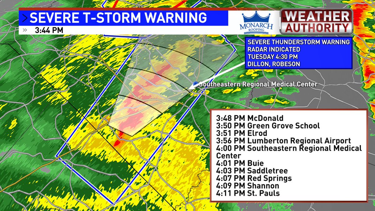
Severe Thunderstorm Warning out now until 4:30pm, moving NE at 60mph for parts of Robeson and Dillon counties This Warning is for 60mph damaging winds and includes a tornado possible tag. Take shelter now within the blue polygon #ncwx #scwx

Severe Thunderstorm Warning out now until 4:30pm, moving NE at 60mph for parts of Robeson and Dillon counties
This Warning is for 60mph damaging winds and includes a tornado possible tag. Take shelter now within the blue polygon #ncwx #scwx
Jenna Storm Warner (@jenstormwarner) 's Twitter Profile Photo

5:47pm- Robeson, Dillon, Marion, Georgetown, Horry, and parts of Williamsburg, Florence, & Columbus counties are in a Severe T-Storm Warning for the line of storms. Expect 60mph damaging winds, small hail, heavy rain, and a tornado remains possible Take shelter now #scwx #ncwx

5:47pm-
Robeson, Dillon, Marion, Georgetown, Horry, and parts of Williamsburg, Florence, &amp; Columbus counties are in a Severe T-Storm Warning for the line of storms. Expect 60mph damaging winds, small hail, heavy rain, and a tornado remains possible
Take shelter now #scwx #ncwx
Sydney Madison (@sydneymadisonw) 's Twitter Profile Photo

You may hate your exes enough to name a roach after them.... but if you really wanna kick it up a notch you may wanna consider a neuter/spay option (for cats of course 😉) 🐈🐈‍⬛

You may hate your exes enough to name a roach after them.... but if you really wanna kick it up a notch you may wanna consider a neuter/spay option (for cats of course 😉) 🐈🐈‍⬛
Ed Piotrowski (@edpiotrowski) 's Twitter Profile Photo

9am - Widespread over Horry and Georgetown counties is headed east. A few embedded non-severe storms with heavy rain and wind gusts up to 40 mph is moving through Georgetown, Pawleys Island and Litchfield bech right now. #scwx #ncwx

Jenna Storm Warner (@jenstormwarner) 's Twitter Profile Photo

Hurricane #Beryl is holding strong, trucking along with 130mph sustained winds, keeping within its track towards the Windward Islands Also this evening, TD 3 has formed (soon to be TS #Chris) in the Bay of Campeche. This storm will move into Mexico's Gulf coast tomorrow

Hurricane #Beryl is holding strong, trucking along with 130mph sustained winds, keeping within its track towards the Windward Islands

Also this evening, TD 3 has formed (soon to be TS #Chris) in the Bay of Campeche. This storm will move into Mexico's Gulf coast tomorrow
National Hurricane Center (@nhc_atlantic) 's Twitter Profile Photo

8am EDT July 10th: NHC is monitoring a trough of low pressure just off the SE U.S. coast. Environmental conditions appear only marginally favorable, & this system has a low (10%🟡) of development over the next couple of days before it moves inland this weekend. Latest:

8am EDT July 10th: NHC is monitoring a trough of low pressure just off the SE U.S. coast. Environmental conditions appear only marginally favorable, &amp; this system has a low (10%🟡) of development over the next couple of days before it moves inland this weekend. 

Latest:
National Hurricane Center (@nhc_atlantic) 's Twitter Profile Photo

Hurricane #Debby Advisory 12A: Debby Just Inland in the Florida Big Bend Region. Expected to Bring Major Flooding Over the Southeastern United States During the Next Few Days. hurricanes.gov