Meredith_Guthrie (@meredithguthr15) 's Twitter Profile
Meredith_Guthrie

@meredithguthr15

Research Scientist @DPIRD with climate. Views expressed are my own

ID: 1073053440610230272

calendar_today13-12-2018 03:14:11

1,1K Tweet

861 Takipçi

182 Takip Edilen

DPIRD Broadacre - WA Grains & Livestock (@dpirdbroadacre) 's Twitter Profile Photo

Slaters and Portuguese millipedes have been found feeding on emerging oats near Grass Patch. Slaters have also recently been reported damaging oats near Kulin and canola near Cascades and Munglinup #PestFactsWA agric.wa.gov.au/newsletters/pe…

Slaters and Portuguese millipedes have been found feeding on emerging oats near Grass Patch. Slaters have also recently been reported damaging oats near Kulin and canola near Cascades and Munglinup #PestFactsWA

agric.wa.gov.au/newsletters/pe…
Bureau of Meteorology, Australia (@bom_au) 's Twitter Profile Photo

Damaging winds are possible about the south coast of #WA associated with a cold front. There is also a risk of damaging gusts with showers and storms across the #Perth area this evening. For more info visit ow.ly/jVlh50SEVq3

Meredith_Guthrie (@meredithguthr15) 's Twitter Profile Photo

It's a bit early to talk about frost - but here are some minimum temperature and number of nights below 2˚C maps from DPIRD Broadacre - WA Grains & Livestock. Bureau of Meteorology, Western Australia Salmon Gums station recorded -2.9˚C, and DPIRDWA Wickepin North has had 9 nights below 2 so far this month. #climate

It's a bit early to talk about frost - but here are some minimum temperature and number of nights below 2˚C maps from <a href="/DPIRDbroadacre/">DPIRD Broadacre - WA Grains & Livestock</a>. <a href="/BOM_WA/">Bureau of Meteorology, Western Australia</a> Salmon Gums station recorded -2.9˚C, and <a href="/DPIRDWA/">DPIRDWA</a> Wickepin North has had 9 nights below 2 so far this month. #climate
Meredith_Guthrie (@meredithguthr15) 's Twitter Profile Photo

After yesterday's rainfall - all locations have finally reached over 100 mm for the year so far, although 100 locations sitting at decile 1, that's nearly a fifth of the South West Land Division. #climate

After yesterday's rainfall - all locations have finally reached over 100 mm for the year so far, although 100 locations sitting at decile 1, that's nearly a fifth of the South West Land Division. #climate
Meredith_Guthrie (@meredithguthr15) 's Twitter Profile Photo

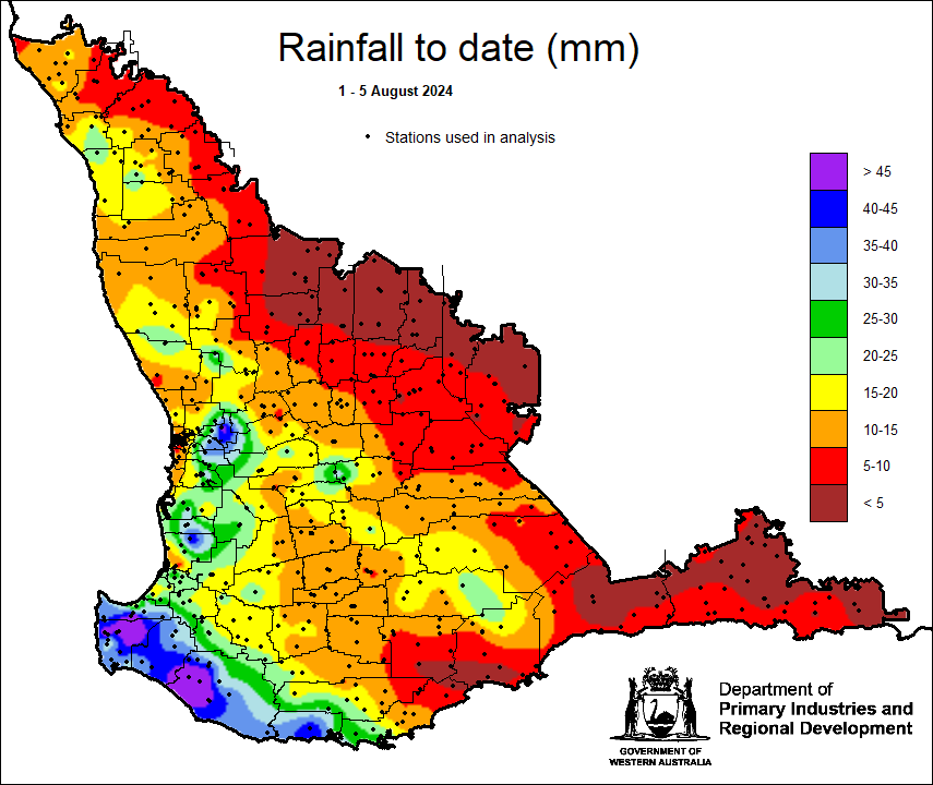
August marks the beginning of the Noongar season of Djilba - very cold and clear days, becoming warmer. Djilba DPIRD Broadacre - WA Grains & Livestock rainfall map from 2023, 2024 should be wetter. Last night's storm brought good rain for Pemberton 51 mm, Pingrup East 22 mm- hopefully no hail. #climate

August marks the beginning of the Noongar season of Djilba - very cold and clear days, becoming warmer.  Djilba <a href="/DPIRDbroadacre/">DPIRD Broadacre - WA Grains & Livestock</a> rainfall map from 2023, 2024 should be wetter. Last night's storm brought good rain for Pemberton 51 mm, Pingrup East 22 mm- hopefully no hail. #climate
Bureau of Meteorology, Australia (@bom_au) 's Twitter Profile Photo

A series of cold fronts are moving over south-west parts of #WesternAustralia through the first half of this week. Showers and storms may bring isolated strong winds and heavy rain to the coast on Tues and Wed. Latest: bom.gov.au

Meredith_Guthrie (@meredithguthr15) 's Twitter Profile Photo

Finally some cold fronts coming through the South West Land Division, all thanks to a negative Southern Annular Mode, bringing cold fronts and westerly winds closer to Australia. 57 mm for Pemberton. Another cold front and strong winds forecast for tonight and Sunday. #climate

Finally some cold fronts coming through the South West Land Division, all thanks to a negative Southern Annular Mode, bringing cold fronts and westerly winds closer to Australia. 57 mm for Pemberton. Another cold front and strong winds forecast for tonight and Sunday. #climate
Bureau of Meteorology, Australia (@bom_au) 's Twitter Profile Photo

Warmer weather is forecast for western and southern #Australia this weekend and into next week with daytime temperatures above the August average. Latest forecasts: bom.gov.au or the BOM Weather app.

Meredith_Guthrie (@meredithguthr15) 's Twitter Profile Photo

More DPIRD Broadacre - WA Grains & Livestock potential yield maps - WUE 12, 15 and 20 kg/mm/ha and rainfall decile map. Winner is Northampton with 4.7 t/ha potential with WUE of 12, least fortunate is Nungarin at 0.9 t/ha. Remember this is potential based on rainfall, not N uptake or anything else!

More <a href="/DPIRDbroadacre/">DPIRD Broadacre - WA Grains & Livestock</a> potential yield maps - WUE 12, 15 and 20 kg/mm/ha and rainfall decile map. Winner is Northampton with 4.7 t/ha potential with WUE of 12, least fortunate is Nungarin at 0.9 t/ha. Remember this is potential based on rainfall, not N uptake or anything else!
Meredith_Guthrie (@meredithguthr15) 's Twitter Profile Photo

Just for you Chris Wilkins - more DPIRD Broadacre - WA Grains & Livestock potential yield maps, this time with different evaporation rates (decile 5 finish and 15 WUE). There is a 0.5 t/ha difference between evp of 90 mm to that of 120 mm. #climate

Just for you <a href="/cmwsynergy/">Chris Wilkins</a> - more <a href="/DPIRDbroadacre/">DPIRD Broadacre - WA Grains & Livestock</a> potential yield maps, this time with different evaporation rates (decile 5 finish and 15 WUE). There is a 0.5 t/ha difference between evp of 90 mm to that of 120 mm. #climate
Bureau of Meteorology, Australia (@bom_au) 's Twitter Profile Photo

Widespread rain, isolated thunderstorms, strong winds & cooler temps to impact much of western & southern #WA this weekend, due to a cold front & low-pressure system. Dangerous, hazardous surf conditions may also develop for parts of the south-west. More: bom.gov

Bureau of Meteorology, Australia (@bom_au) 's Twitter Profile Photo

We don't often see fronts like this over Australia! The purple line with triangles & circles represents an occluded front, which usually occur further south. They form when a cold front wedges under a warm front, leading to cloud formation & rain. More: ow.ly/o7VA50T0N5N

We don't often see fronts like this over Australia! The purple line with triangles &amp; circles represents an occluded front, which usually occur further south. They form when a cold front wedges under a warm front, leading to cloud formation &amp; rain. 
More: ow.ly/o7VA50T0N5N
Meredith_Guthrie (@meredithguthr15) 's Twitter Profile Photo

Updated DPIRD Broadacre - WA Grains & Livestock Growing season rainfall to date maps. Everywhere have passed the 100 mm so far since 1 April. Ongerup 109 mm, Northcliffe 816 mm. Still a bit of red on the decile map. Hoping for a kind spring. #climate

Updated <a href="/DPIRDbroadacre/">DPIRD Broadacre - WA Grains & Livestock</a> Growing season rainfall to date maps. Everywhere have passed the 100 mm so far since 1 April. Ongerup 109 mm, Northcliffe 816 mm. Still a bit of red on the decile map. Hoping for a kind spring. #climate
Meredith_Guthrie (@meredithguthr15) 's Twitter Profile Photo

A very wet 2 months thanks to a negative Southern Annular Mode. DPIRD Broadacre - WA Grains & Livestock rainfall maps 1 July-29 August. Lots of blue, Yuna 158 mm. A few decile 2 locations - Tamar 148, Gairdner 86 and Ravensthorpe 75 mm. #climate

A very wet 2 months thanks to a negative Southern Annular Mode. <a href="/DPIRDbroadacre/">DPIRD Broadacre - WA Grains & Livestock</a> rainfall maps 1 July-29 August. Lots of blue, Yuna 158 mm. A few decile 2 locations - Tamar 148, Gairdner 86 and Ravensthorpe 75 mm. #climate
DPIRD Broadacre - WA Grains & Livestock (@dpirdbroadacre) 's Twitter Profile Photo

The Pastures from Space tool can be used to identify your feed on offer, compare to previous years and help predict feed on offer for the rest of the season. Search your PIC to check out how your property is tracking 🌏 pasturesfromspace.dpird.wa.gov.au/#/map

The Pastures from Space tool can be used to identify your feed on offer, compare to previous years and help predict feed on offer for the rest of the season. Search your PIC to check out how your property is tracking 🌏 pasturesfromspace.dpird.wa.gov.au/#/map
Meredith_Guthrie (@meredithguthr15) 's Twitter Profile Photo

So far this spring DPIRD Broadacre - WA Grains & Livestock rain to date map, Pemberton 70 mm, Bencubbin 0.6 mm. Some frost, Bonnie Rock (-1.6C) and Kulin both have 4 nights below 2C so far. Higher temps, Ridley North 32.7, Yuna NE 31.8. Northampton forecast 32C this Saturday. #climate

So far this spring <a href="/DPIRDbroadacre/">DPIRD Broadacre - WA Grains & Livestock</a> rain to date map, Pemberton 70 mm, Bencubbin 0.6 mm. Some frost, Bonnie Rock (-1.6C) and Kulin both have 4 nights below 2C so far. Higher temps, Ridley North 32.7, Yuna NE 31.8. Northampton forecast 32C this Saturday. #climate