ArchAI
@ARCHAI_LTD
ArchAI uses AI to automatically detect archaeological sites on earth observation data
ID:1287736415288209408
http://www.archai.io 27-07-2020 13:08:09
110 Tweets
713 Followers
396 Following
🌊 Intern with ArchAI this summer! Analyse historical landscape changes at the coast using GIS and AI. Make a real impact on environmental research and collaborate with experts. Remote - starts June 2024. Apply by Mar 20: app.beapplied.com/apply/am03kghy… #EnvironmentalScience #TechForGood
🚀 Dive into #Archaeology with ArchAI this summer! 🛰️ Explore ancient sites using satellite imagery and #AI , and sharpen your skills in data analysis. Remote internship, starts June 2024. 🌍 Apply by Mar 6: app.beapplied.com/apply/laubcrpn… #TechInternship #Innovation
(@creativedlab) 's Twitter Profile Photo")
 's Twitter Profile Photo")
 on Twitter photo 2023-04-21 09:07:42 Very excited to be speaking today at the Heritage sustainability for climate and nature session at #CIfA2023. I'm speaking about @ARCHAI_LTD's #AI derived national maps of heritage assets and how these datasets are used by our clients to create sustainable places.")
🎉 It's a real honour being selected as one of the Innovate UK Women in Innovation Award winners.
The award comes with £50,000 and will support ArchAI's mission to de-risk development by detecting historic risks in the landscape.
#WomenInnovate #IWD2023 #WomeninGeospatial
 on Twitter photo 2023-03-08 11:31:18 🎉 It's a real honour being selected as one of the @innovateuk Women in Innovation Award winners. The award comes with £50,000 and will support @ARCHAI_LTD's mission to de-risk development by detecting historic risks in the landscape. #WomenInnovate #IWD2023 #WomeninGeospatial")
 on Twitter photo 2023-02-26 15:25:24 This morning we were featured on BBC #PoliticsSouth talking about how ArchAI is using #AI to detect historic sites in the landscape. 🤯🤯 You can find the feature on the @BBC iPlayer from around 15:30 bbc.co.uk/iplayer/episod…")
We had an amazing time last week at the #ArchaeologicalAchievementAwards at Dublin Castle last week. Unfortunately we did not win but it was great to meet the Innovation winners behind Uist Unearthed project. Congratulations to all the winners!
Really excited to be in Dublin for the #ArchaeologicalAchievement awards! I look forward to meeting all the shortlisted candidates tonight and celebrate innovation! 🥳
We're really honoured to be shortlisted for the #ArchaeologicalAchievement innovaton award! 🎉
We look forward to meeting all the candidates in Dublin and celebrate innovation!
 on Twitter photo 2022-01-04 08:03:00 We have put together a couple of images with predictions that show all the different site types that we have trained our #AI on in the Isle of Arran, Scotland. What do you think?")
 on Twitter photo 2022-05-31 07:01:00 Archaeologists, what data would you ideally want to get from a ridge and furrow survey? At the moment, for each AI detected field, we can extract ridge height, width, direction, slope, aspect and altitude. We use these parameters to assign a historic period and confidence score.")
 's Twitter Profile Photo")
 on Twitter photo 2022-05-10 14:19:26 Fantastic to see @ARCHAI_LTD present in the Rising Stars Plenary at #GWF2022 @Geovation @Ordnancesurvey")
We were on the Dutch national TV!! Iris spoke about our innovative technology and how we save time and money for construction projects. Even had the opportunity to mention our National Trust project on detecting historic orchards at national scale!
HUGE congrats to our founder Dr Iris Kramer for being included in the Forbes Under 30 science list for 2022! 👏👏
#ForbesUnder30 #forbes30under30 linkedin.com/posts/ickramer…
 's Twitter Profile Photo")
 on Twitter photo 2022-04-16 09:00:02 As archaeologists, we need to be aware of developing policy & practice relating to the rural economy and the natural environment. Join the IN OUR NATURE? session at #CIfA2022 to explore the challenges and opportunities facing our sector. Register here: bit.ly/3xdgRGR")
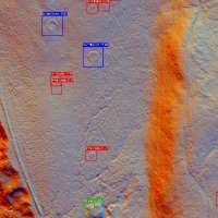
In our project for the Forestry Commission we used Environment Agency #LiDAR data to detect ridge and furrow in Northumberland and assess the preservation of those earthworks.
We will present our latest projects and how we create landscape scale solutions at #CIfA2022 this Friday.
 on Twitter photo 2022-04-26 14:41:31 In our project for the @ForestryComm we used @EnvAgency #LiDAR data to detect ridge and furrow in Northumberland and assess the preservation of those earthworks. We will present our latest projects and how we create landscape scale solutions at #CIfA2022 this Friday.")
We were given the great opportunity to present ArchAI at the #CambridgeConference UK Showcase.
It was great to meet senior leaders from the international delegation as well as lots of leading UK #geospatial organisations.
Thanks Ordnance Survey and Geovation!
 on Twitter photo 2022-04-13 14:32:29 We were given the great opportunity to present ArchAI at the #CambridgeConference UK Showcase. It was great to meet senior leaders from the international delegation as well as lots of leading UK #geospatial organisations. Thanks @OrdnanceSurvey and @Geovation!")