Meteorologist Lucy Doll(@LucyDollWx) 's Twitter Profileg
Meteorologist Lucy Doll

@LucyDollWx

Meteorologist at @ksnnews | #MizzouMade | KC native | KS ➡️ MO ➡️ LA ➡️ KS | All opinions are my own | #kswx

ID:1020395035399946242

linkhttps://www.ksn.com/weather/ calendar_today20-07-2018 19:48:29

8,6K Tweets

3,1K Followers

3,4K Following

Chief Meteorologist Lisa Teachman(@LisaTeachman) 's Twitter Profile Photo


It was a Party for the Planet at the Sedgwick County Zoo . We had students from all over stop by to talk about weather with Meteorologist Lucy Doll and me. The chill did not stop anybody from checking out Storm Tracker 3. More photos available on Facebook.

KSN News Wichita KSN Storm Track 3

#kswx It was a Party for the Planet at the @SedgwickCoZoo . We had students from all over stop by to talk about weather with @LucyDollWx and me. The chill did not stop anybody from checking out Storm Tracker 3. More photos available on Facebook. @KSNNews @KSNStormTrack3…
account_circle
Ronelle Williams(@rnllwilliamswx) 's Twitter Profile Photo

RADAR UPDATE: Strong storms are almost out of the area as they track to the east. There will still be some showers and rumbles around today to the north and west. Brace yourselves for another windy day too. KSN News Wichita KSN Storm Track 3 ksn.com/weather/

account_circle
Chief Meteorologist Lisa Teachman(@LisaTeachman) 's Twitter Profile Photo


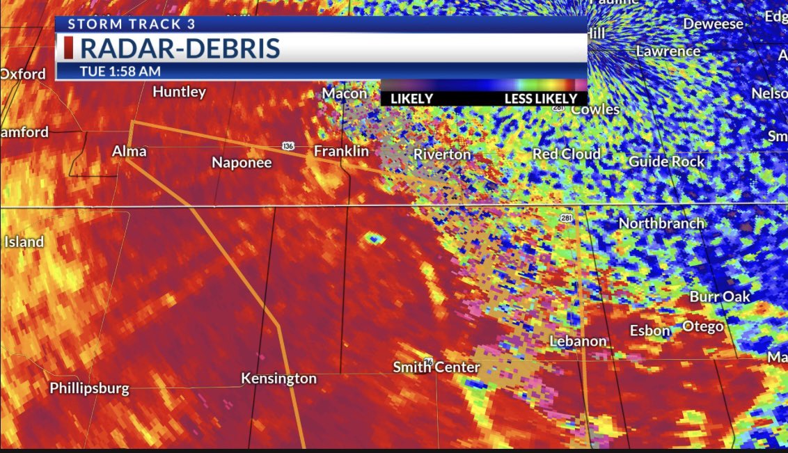
A TORNADO was reported 13 miles north of Athol in Smith County, Kansas, early Tuesday morning just before 2 AM. Apparent tornado debris signature developed on Hastings' Radar at this location and time.  The TDS ended around 2:05 AM CDT in southern Nebraska in…

#kswx #newx A TORNADO was reported 13 miles north of Athol in Smith County, Kansas, early Tuesday morning just before 2 AM. Apparent tornado debris signature developed on Hastings' Radar at this location and time.  The TDS ended around 2:05 AM CDT in southern Nebraska in…
account_circle
Meteorologist Lucy Doll(@LucyDollWx) 's Twitter Profile Photo

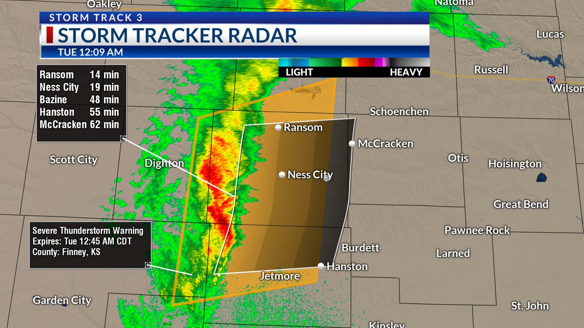
A SEVERE THUNDERSTORM WARNING has been issued for Hodgeman, Trego, Finney, Ness, Lane, and Gray counties through 12:45 AM Tuesday. This line of storms is tracking east at 25 MPH and producing small hail and 60 MPH wind gusts. ksn.com/weather
KSN News Wichita KSN Storm Track 3

A SEVERE THUNDERSTORM WARNING has been issued for Hodgeman, Trego, Finney, Ness, Lane, and Gray counties through 12:45 AM Tuesday. This line of storms is tracking east at 25 MPH and producing small hail and 60 MPH wind gusts. ksn.com/weather @KSNNews @KSNStormTrack3 #kswx
account_circle
Meteorologist Lucy Doll(@LucyDollWx) 's Twitter Profile Photo

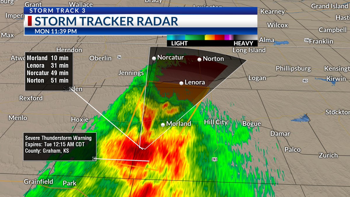
A SEVERE THUNDERSTORM WARNING has been issued for Graham, Sheridan, and Norton counties through 12:15 AM Tuesday. This storm is tracking north at 50 MPH and is capable of producing quarter sized hail and 60 MPH winds gusts.
ksn.com/weather
KSN News Wichita KSN Storm Track 3

A SEVERE THUNDERSTORM WARNING has been issued for Graham, Sheridan, and Norton counties through 12:15 AM Tuesday. This storm is tracking north at 50 MPH and is capable of producing quarter sized hail and 60 MPH winds gusts. ksn.com/weather @KSNNews @KSNStormTrack3 #kswx
account_circle
Chief Meteorologist Lisa Teachman(@LisaTeachman) 's Twitter Profile Photo

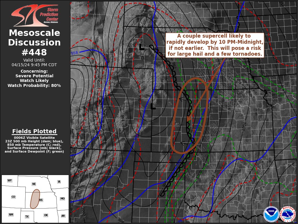
WATCH LIKELY! The area circled is being monitored for a weather watch within the next hour or two. A few tornadoes are possible overnight along with areas of large hail and damaging winds. Stay with KSN News Wichita KSN Storm Track 3 for updates.

ksn.com/weather

WATCH LIKELY! The area circled is being monitored for a weather watch within the next hour or two. A few tornadoes are possible overnight along with areas of large hail and damaging winds. Stay with @KSNNews @KSNStormTrack3 for updates. #kswx ksn.com/weather
account_circle
Chief Meteorologist Lisa Teachman(@LisaTeachman) 's Twitter Profile Photo


STORM TRACK 3 FORECAST: Severe storms are possible into the overnight. This will be an unsettled week for us on the Central Plains with two more storm systems lined up before we hit the weekend. What each brings and what you need to know in your updated…

#kswx #okwx #newx STORM TRACK 3 FORECAST: Severe storms are possible into the overnight. This will be an unsettled week for us on the Central Plains with two more storm systems lined up before we hit the weekend. What each brings and what you need to know in your updated…
account_circle
KDEM(@KansasEmergency) 's Twitter Profile Photo

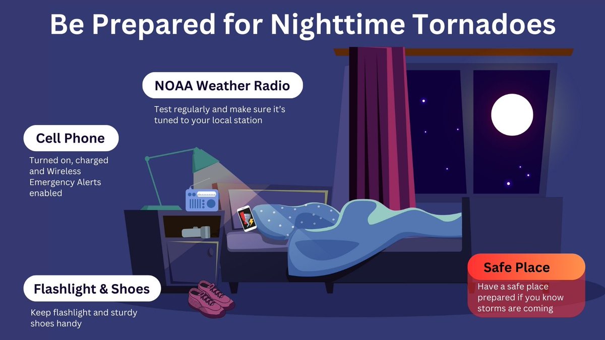
Sleep with your phone on and have a plan! There is a potential for nighttime tornadoes in Kansas tonight. Pay close attention to the weather and be ready to act.
Governor Laura Kelly | | |

Sleep with your phone on and have a plan! There is a potential for nighttime tornadoes in Kansas tonight. Pay close attention to the weather and be ready to act. @GovLauraKelly | #beprepared | #kswx | #NWS
account_circle
Chief Meteorologist Lisa Teachman(@LisaTeachman) 's Twitter Profile Photo


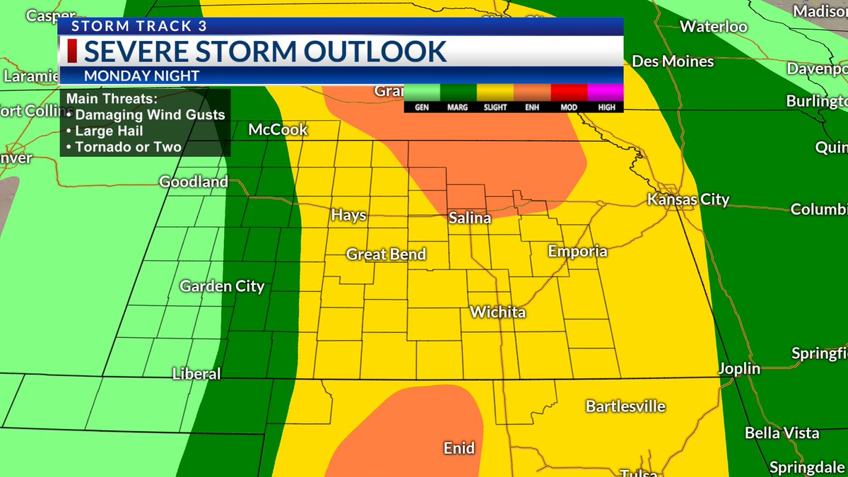
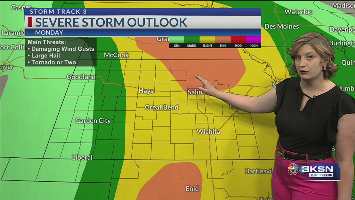
SEVERE STORM RISK: Here is a breakdown where severe weather is possible into the overnight with the highest probabilities for tornadoes, large hail and damaging winds. Stay with KSN News Wichita KSN Storm Track 3 for updates.
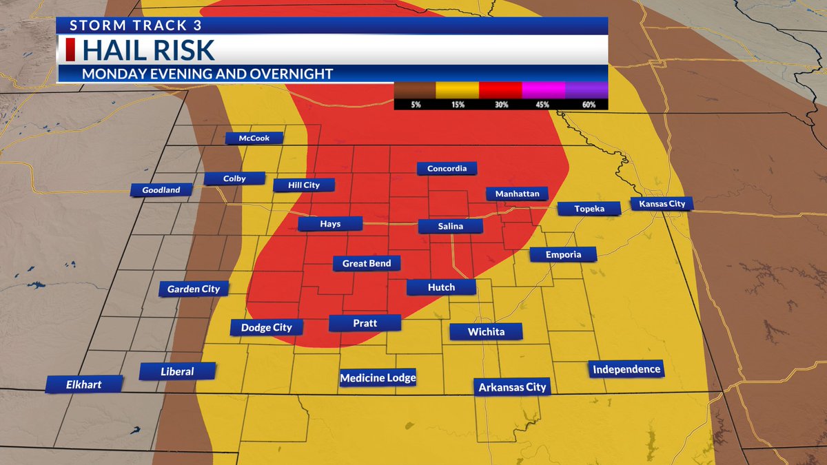
#kswx #okwx #newx SEVERE STORM RISK: Here is a breakdown where severe weather is possible into the overnight with the highest probabilities for tornadoes, large hail and damaging winds. Stay with @KSNNews @KSNStormTrack3 for updates.
account_circle
NWS Storm Prediction Center(@NWSSPC) 's Twitter Profile Photo

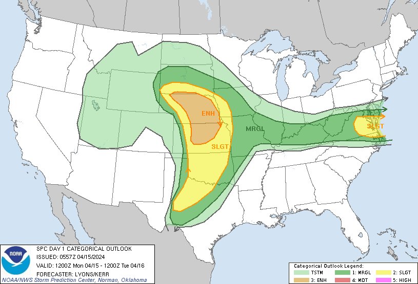
12:59am CDT Day1 Outlook Enhanced Risk: Across portions of South Dakota, Nebraska, and Kansas spc.noaa.gov/products/outlo…

12:59am CDT #SPC Day1 Outlook Enhanced Risk: Across portions of South Dakota, Nebraska, and Kansas spc.noaa.gov/products/outlo…
account_circle
Meteorologist Lucy Doll(@LucyDollWx) 's Twitter Profile Photo

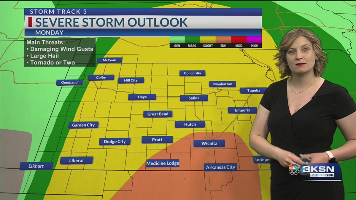
All of the ingredients for severe weather will be in place for the Sunflower State tomorrow. Storms will begin to ignite in the late evening and overnight. All forms of severe weather will be possible.

ksn.com/weather

KSN News Wichita KSN Storm Track 3

All of the ingredients for severe weather will be in place for the Sunflower State tomorrow. Storms will begin to ignite in the late evening and overnight. All forms of severe weather will be possible. ksn.com/weather @KSNNews @KSNStormTrack3 #kswx
account_circle
Meteorologist Lucy Doll(@LucyDollWx) 's Twitter Profile Photo

Fire weather concerns increase tomorrow as strong winds return to the region. Temps will climb into the 80s by the afternoon. All of the ingredients will be in place for any storm that forms to become strong to severe.
ksn.com/weather/weathe…
KSN News Wichita KSN Storm Track 3

Fire weather concerns increase tomorrow as strong winds return to the region. Temps will climb into the 80s by the afternoon. All of the ingredients will be in place for any storm that forms to become strong to severe. ksn.com/weather/weathe… @KSNNews @KSNStormTrack3 #kswx
account_circle
Meteorologist Lucy Doll(@LucyDollWx) 's Twitter Profile Photo

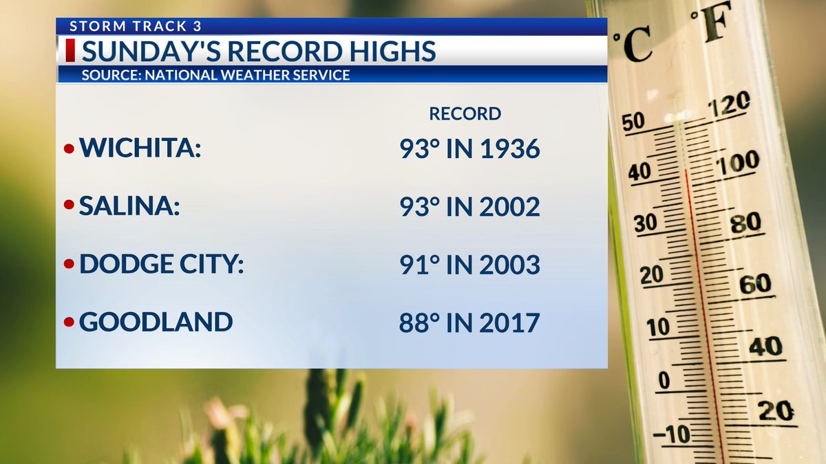
Toasty temperatures tomorrow are expected to reach into the 80s and 90s across the region under sunny skies. Highs will be near a few records across the region.
KSN News Wichita KSN Storm Track 3

Toasty temperatures tomorrow are expected to reach into the 80s and 90s across the region under sunny skies. Highs will be near a few records across the region. @KSNNews @KSNStormTrack3 #kswx
account_circle
Meteorologist Lucy Doll(@LucyDollWx) 's Twitter Profile Photo

Toasty temps to end the weekend with highs tomorrow flirting with the 90s. Storm chances return late Monday night into Tuesday, with all modes of severe weather possible.
ksn.com/video/storm-tr…
KSN News Wichita KSN Storm Track 3

Toasty temps to end the weekend with highs tomorrow flirting with the 90s. Storm chances return late Monday night into Tuesday, with all modes of severe weather possible. ksn.com/video/storm-tr… @KSNNews @KSNStormTrack3 #kswx
account_circle