Nutrien Ag Solutions - Weather Insights(@ag_weather) 's Twitter Profileg
Nutrien Ag Solutions - Weather Insights

@ag_weather

Nutrien Ag Solutions Ag Weather Team

ID:1371838800033419270

linkhttps://ag-wx.com/ calendar_today16-03-2021 15:02:18

586 Tweets

1,5K Followers

30 Following

Nutrien Ag Solutions - Weather Insights(@ag_weather) 's Twitter Profile Photo

Very heavy lake effect snow fell in narrow bands around Lake Michigan and Lake Superior yesterday. Winter Storm Warnings remain for the UP of Michigan where 40-60 mph winds are possible with an additional 2-4' of snow. 2-4' of snow fell in parts of north Indiana yesterday.

account_circle
Nutrien Ag Solutions(@NutrienAgRetail) 's Twitter Profile Photo

Today is all about you—the grower! It’s , and we’re celebrating all that you do to feed the world. We’re proud to be with you.

🎵: Woodkid - Run Boy Run

account_circle
Andrew Pritchard(@skydrama) 's Twitter Profile Photo

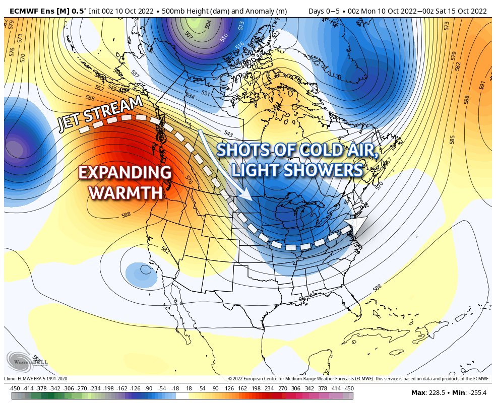
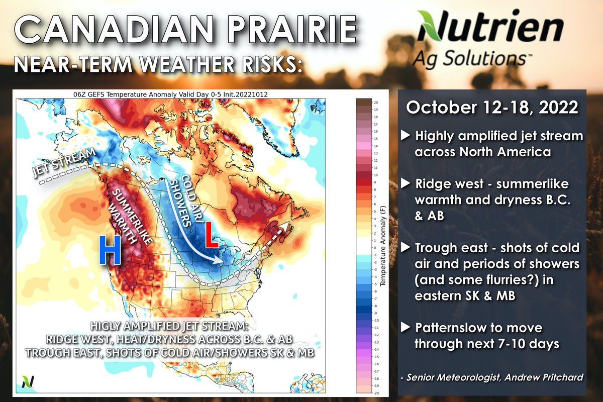
Canadian Prairie: Highly amplified jet stream across North America leaves the pattern rather unchanged across western Canada. Ridge west keeps summer-like warmth and dryness over B.C., AB, west SK. Shots of cold air, periods of showers rotate around upper-level low in the east.

Canadian Prairie: Highly amplified jet stream across North America leaves the pattern rather unchanged across western Canada. Ridge west keeps summer-like warmth and dryness over B.C., AB, west SK. Shots of cold air, periods of showers rotate around upper-level low in the east.
account_circle
Andrew Pritchard(@skydrama) 's Twitter Profile Photo

Ridge west, trough east... pattern continues to reload across western Canada with shots of cold, dry air and generally light, hit-or-miss shower chances.

Canadian Prairie Weather Story with Andrew Pritchard | October 10th, 2022 youtu.be/HXEXvtsYHps via YouTube

account_circle
Nutrien Ag Solutions - Weather Insights(@ag_weather) 's Twitter Profile Photo

Ridge west, trough east... pattern continues to reload across western Canada with shots of cold, dry air and generally light, hit-or-miss shower chances.

Today's Canadian Prairie Weather Story weekly forecast video: youtu.be/HXEXvtsYHps

Ridge west, trough east... pattern continues to reload across western Canada with shots of cold, dry air and generally light, hit-or-miss shower chances. Today's Canadian Prairie Weather Story weekly forecast video: youtu.be/HXEXvtsYHps
account_circle
Nutrien Ag Solutions - Weather Insights(@ag_weather) 's Twitter Profile Photo

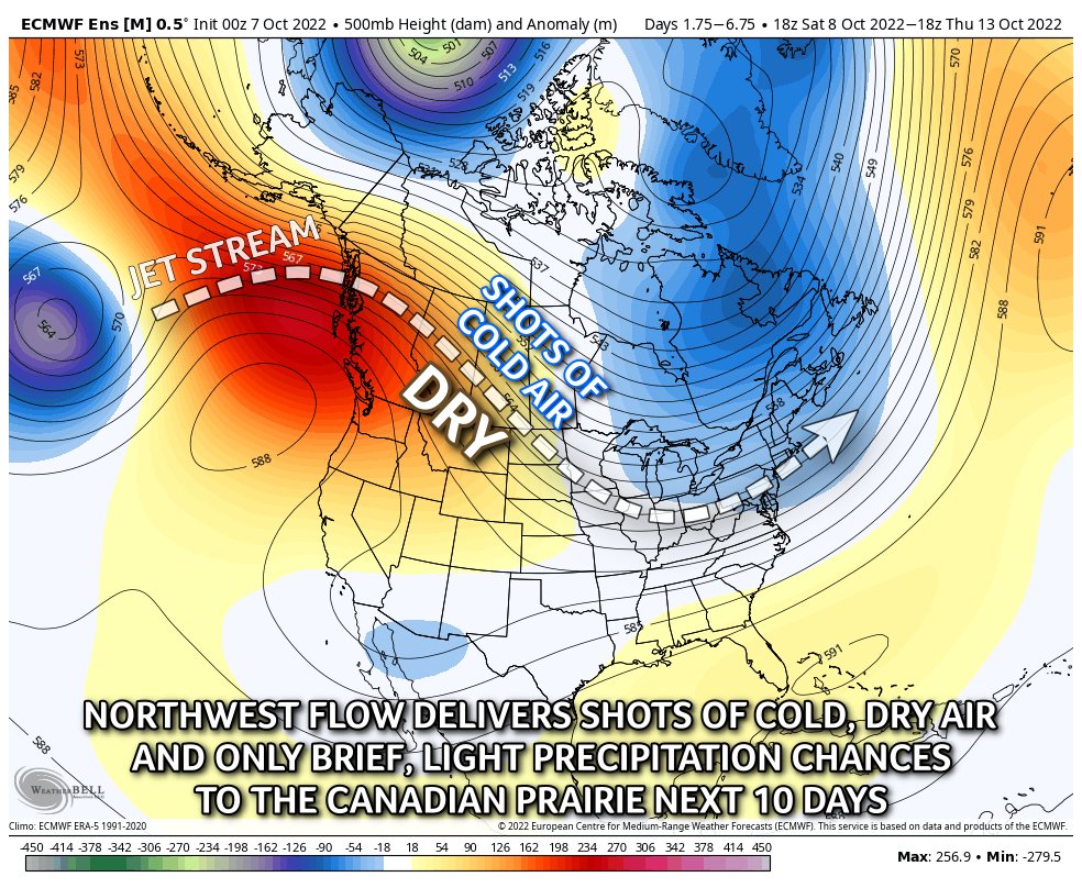
Very similar pattern to Fall/early Winter 2021 across western Canada over the next two weeks.

Expect variable temps - shots of cold, dry air followed by increasingly mild days & only brief, light opportunities for precipitation accompanying passing frontal boundaries.

Very similar pattern to Fall/early Winter 2021 across western Canada over the next two weeks. Expect variable temps - shots of cold, dry air followed by increasingly mild days & only brief, light opportunities for precipitation accompanying passing frontal boundaries.
account_circle
Andrew Pritchard(@skydrama) 's Twitter Profile Photo

A shot of cold, dry air spills out of Canada into the central U.S. this weekend. The animation below shows the dew point temperature over the next 10 days.

Note, as high pressure moves east, deep Gulf moisture begins to return in days 7-10.

account_circle
Nutrien Ag Solutions - Weather Insights(@ag_weather) 's Twitter Profile Photo

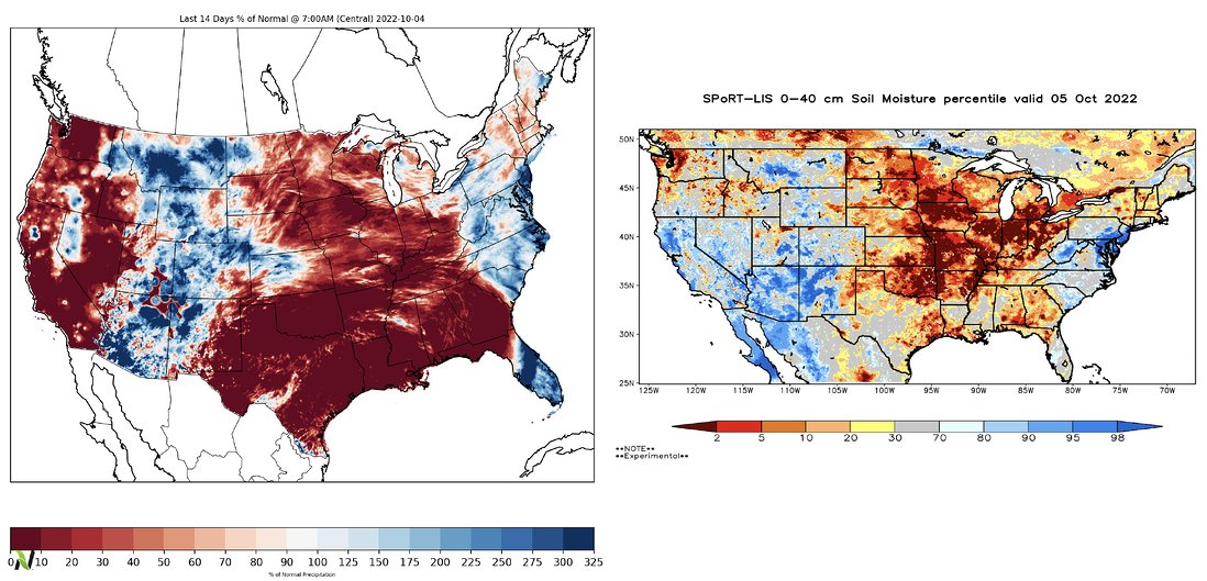
Last 14-days % of Normal Rains (left) and 16' Soil Moisture Data from NASA (right)

Fall 2022 is off to a very dry start across a wide swath of the central U.S.

Last 14-days % of Normal Rains (left) and 16' Soil Moisture Data from NASA (right) Fall 2022 is off to a very dry start across a wide swath of the central U.S.
account_circle
Andrew Pritchard(@skydrama) 's Twitter Profile Photo

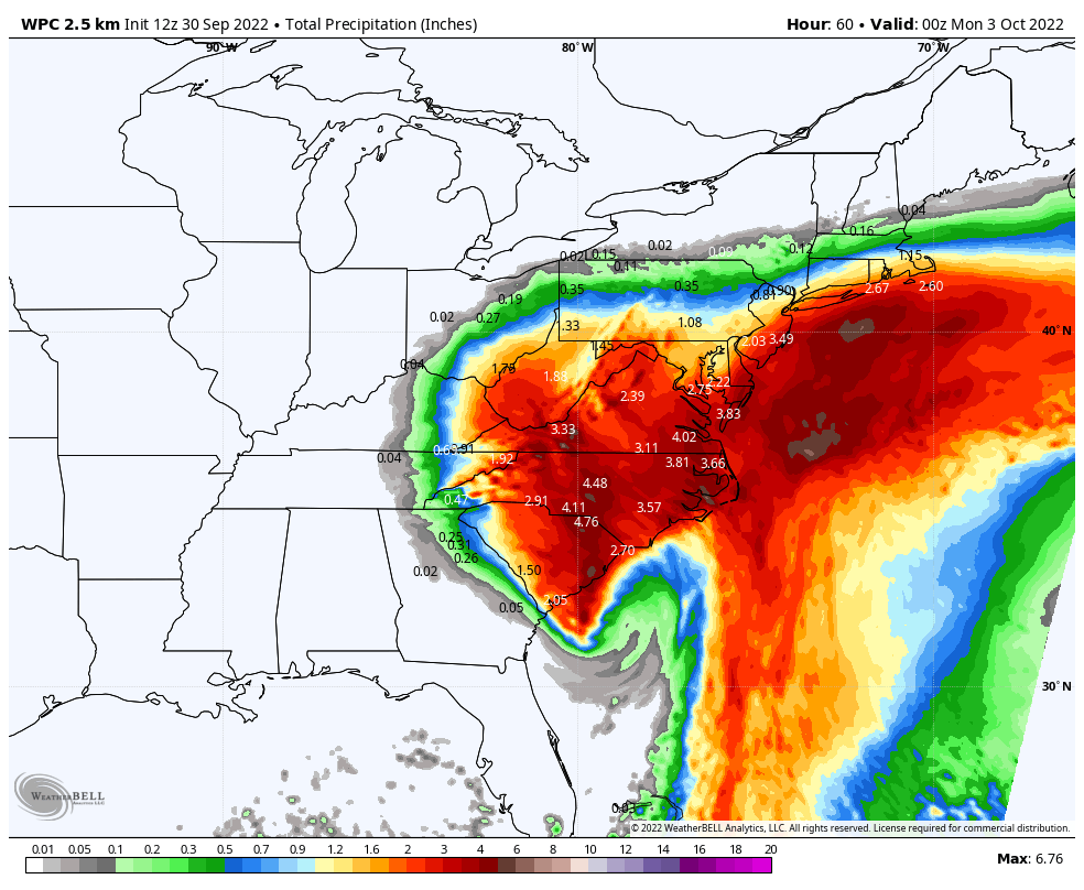
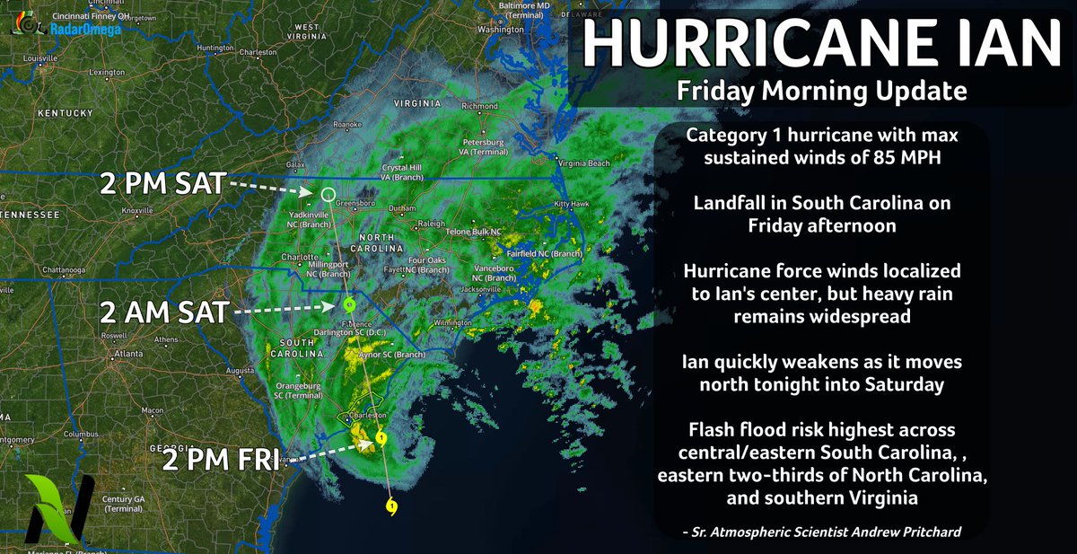
Ian will rapidly lose strength and begin to dissipate after making landfall tonight into Saturday. Still, corridors of locally heavy rainfall may continue into the Mid-Atlantic and Northeast through Sunday.

Ian will rapidly lose strength and begin to dissipate after making landfall tonight into Saturday. Still, corridors of locally heavy rainfall may continue into the Mid-Atlantic and Northeast through Sunday.
account_circle
Andrew Pritchard(@skydrama) 's Twitter Profile Photo

Hurricane Ian remains a Cat 1 with max sustained winds of 85 mph, center located approximately 105 miles SSE of Charleston, SC. Ian continues to wobble NE this AM but is expected to slowly curve to the NW and make another landfall on the coast of South Carolina this afternoon.

Hurricane Ian remains a Cat 1 with max sustained winds of 85 mph, center located approximately 105 miles SSE of Charleston, SC. Ian continues to wobble NE this AM but is expected to slowly curve to the NW and make another landfall on the coast of South Carolina this afternoon.
account_circle
Andrew Pritchard(@skydrama) 's Twitter Profile Photo

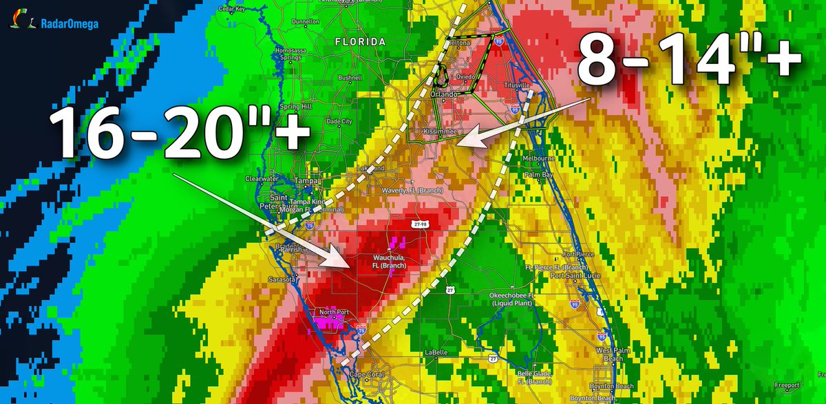
Incredible rainfall totals continue to stack up along the northern side of Ian's track through central Florida. 16 to 20 inches of rain fell from around North Port to Wauchula, with 8-14' totals in Orland and Daytona Beach where a Flash Flood Emergency is in effect.

Incredible rainfall totals continue to stack up along the northern side of Ian's track through central Florida. 16 to 20 inches of rain fell from around North Port to Wauchula, with 8-14' totals in Orland and Daytona Beach where a Flash Flood Emergency is in effect.
account_circle
Andrew Pritchard(@skydrama) 's Twitter Profile Photo

Friday into the weekend, Ian is expected to curve back toward the west, delivering heavy rainfall of 3-6”+ and gusty winds to portions of Georgia and the Carolinas.

The next 24 hours will be among the worst experienced by this region of western Florida in several decades.

account_circle
Andrew Pritchard(@skydrama) 's Twitter Profile Photo

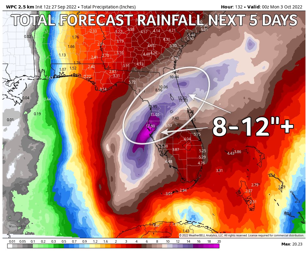
Rainfall will continue to be significant, with 10-15”+ totals expected across all of central Florida. While maximum winds will subside on Thursday, tropical storm force winds will still have little problem falling trees with oversaturated soils from heavy rains.

Rainfall will continue to be significant, with 10-15”+ totals expected across all of central Florida. While maximum winds will subside on Thursday, tropical storm force winds will still have little problem falling trees with oversaturated soils from heavy rains.
account_circle
Andrew Pritchard(@skydrama) 's Twitter Profile Photo

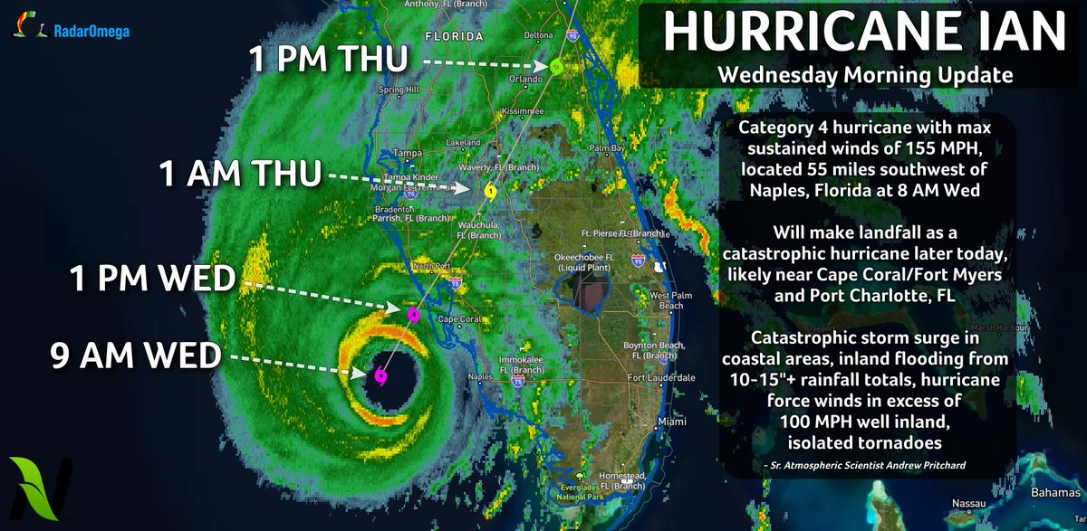
On Wednesday AM, Hurricane Ian is a category 4 storm with maximum sustained winds of 155 MPH. The center of Ian was located around 50 miles west of Naples, Florida at 9 AM CT. Ian will make landfall later today as a catastrophic hurricane near Cape Coral on Florida’s west coast.

On Wednesday AM, Hurricane Ian is a category 4 storm with maximum sustained winds of 155 MPH. The center of Ian was located around 50 miles west of Naples, Florida at 9 AM CT. Ian will make landfall later today as a catastrophic hurricane near Cape Coral on Florida’s west coast.
account_circle
Andrew Pritchard(@skydrama) 's Twitter Profile Photo

I am extremely concerned about our Nutrien Ag Solutions facilities in Tampa, Mulberry, Parrish, Wauchula, and Waverly as they face a prolonged period of high winds + heavy rains on Thursday.
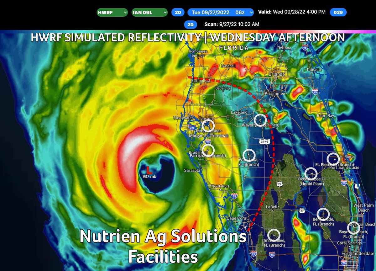
I am extremely concerned about our @NutrienAgRetail facilities in Tampa, Mulberry, Parrish, Wauchula, and Waverly as they face a prolonged period of high winds + heavy rains on Thursday.
account_circle
Andrew Pritchard(@skydrama) 's Twitter Profile Photo

On Wednesday, the risk for tornadoes and flooding rains lifts north into Central Florida as the center of Hurricane Ian approaches western Florida.

Landfall is expected near Tampa, FL late Wed PM into Thu AM as Hurricane Ian slows to a forward speed of less than 5 MPH.

On Wednesday, the risk for tornadoes and flooding rains lifts north into Central Florida as the center of Hurricane Ian approaches western Florida. Landfall is expected near Tampa, FL late Wed PM into Thu AM as Hurricane Ian slows to a forward speed of less than 5 MPH.
account_circle
Andrew Pritchard(@skydrama) 's Twitter Profile Photo

Hurricane Ian, now a Category 3 hurricane with max sustained winds of 125 MPH emerges over the Gulf of Mexico west of Florida today.

Even with its center some 200 miles away, the risk for isolated tornadoes and flooding rains increases today across South Florida.

Hurricane Ian, now a Category 3 hurricane with max sustained winds of 125 MPH emerges over the Gulf of Mexico west of Florida today. Even with its center some 200 miles away, the risk for isolated tornadoes and flooding rains increases today across South Florida.
account_circle
Andrew Pritchard(@skydrama) 's Twitter Profile Photo

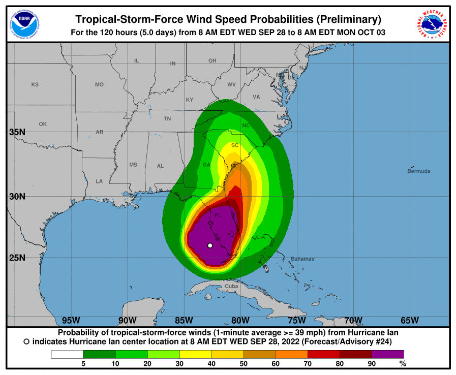
The latest update from National Hurricane Center reflects the idea that Hurricane Ian will slow to a crawl (< 5 MPH) on Thursday.

This will expose a large swath of the western coast of Florida, including the Tampa area, to a prolonged period of storm surge, high winds, & heavy rains.
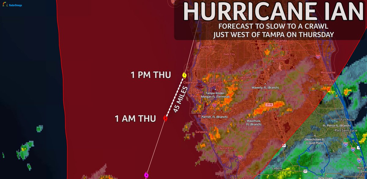
The latest update from @NHC_Atlantic reflects the idea that Hurricane Ian will slow to a crawl (< 5 MPH) on Thursday. This will expose a large swath of the western coast of Florida, including the Tampa area, to a prolonged period of storm surge, high winds, & heavy rains.
account_circle