Chris Holmes (@opencholmes) 's Twitter Profile
Chris Holmes

@opencholmes

Working towards Cloud-Native Geospatial, through involvement in @GeoParquet, @planet, @STACSpec, @cogeotiff, @cloudnativegeo & @source_coop.

ID: 1427817540

linkhttps://cholmes.medium.com/ calendar_today14-05-2013 13:27:37

2,2K Tweet

4,4K Followers

153 Following

Darren Wiens (@dkwiens) 's Twitter Profile Photo

A lot of people fall into the trap of loading data as fast as possible. I say, take your time with it. Introducing, Pencil Map: pencil-map.netlify.app

Archie (@archieemwood) 's Twitter Profile Photo

one of the more awesome things you can do with DuckDB query geospatial data straight from github this is from the excellent Natural Earth Data, and contains the boundaries for all countries in the world

one of the more awesome things you can do with <a href="/duckdb/">DuckDB</a> 

query geospatial data straight from github

this is from the excellent Natural Earth Data, and contains the boundaries for all countries in the world
Kyle Barron @kylebarron@mapstodon.space (@kylebarron2) 's Twitter Profile Photo

The GeoParquet 1.1 revision is out, adding support for spatial partitioning and native GeoArrow geometries Both have potential to massively speed up working with very large geospatial datasets. Next step is ensuring the ecosystem works with this version github.com/opengeospatial…

DuckDB Labs (@duckdblabs) 's Twitter Profile Photo

We recently sponsored Hack4Her, a female-focused student hackathon in the Netherlands. During the DuckDB Challenge of the event, teams built a community-driven app providing safe walking routes in Amsterdam using DuckDB and its geospatial library. networkinstitute.org/2024/06/18/hac…

We recently sponsored Hack4Her, a female-focused student hackathon in the Netherlands. During the DuckDB Challenge of the event, teams built a community-driven app providing safe walking routes in Amsterdam using DuckDB and its geospatial library.

networkinstitute.org/2024/06/18/hac…
Kyle Barron @kylebarron@mapstodon.space (@kylebarron2) 's Twitter Profile Photo

Really exciting to see GeoPandas 1.0 released! Among a bunch of new features I'm most excited about native GeoArrow interoperability! Remember to pass use_arrow=True in geopandas.read_file for best performance! github.com/geopandas/geop…

Cloud-Native Geospatial Foundation (@cloudnativegeo) 's Twitter Profile Photo

New blog post by Matthias Mohr explores a practical solution for analysis-ready data: A SpatioTemporal Asset Catalog-based approach for CEOS-ARD. Read it now and share your thoughts! cloudnativegeo.org/blog/2024/06/a…

New blog post by <a href="/matthmohr/">Matthias Mohr</a> explores a practical solution for analysis-ready data: A <a href="/STACspec/">SpatioTemporal Asset Catalog</a>-based approach for CEOS-ARD. Read it now and share your thoughts! cloudnativegeo.org/blog/2024/06/a…
Ibis (@ibisdata) 's Twitter Profile Photo

Did you know you can reliably query 10X larger-than-RAM datasets with Python dataframes thanks to DuckDB? The threshold for "big" data is larger than ever. ibis-project.org/posts/1tbc

Cloud-Native Geospatial Foundation (@cloudnativegeo) 's Twitter Profile Photo

The initial goal of GeoParquet might have been modest. Its ultimate goal is a future where #geospatial data is integrated across the data landscape. Read Chris Holmes & Javier de la Torre's blog post to learn more about breaking the 'GIS' data silo. cloudnativegeo.org/blog/2024/07/e…
The initial goal of <a href="/GeoParquet/">GeoParquet</a> might have been modest. Its ultimate goal is a future where #geospatial data is integrated across the data landscape. Read <a href="/opencholmes/">Chris Holmes</a> &amp; <a href="/jatorre/">Javier de la Torre</a>'s blog post to learn more about breaking the 'GIS' data silo.
cloudnativegeo.org/blog/2024/07/e…
Planet (@planet) 's Twitter Profile Photo

The countdown is complete! #WildWildSpace is now streaming on Max in the US. From Planet’s early days, to our upcoming launches, we are thrilled to share the excitement and promise of space with audiences around the world. hbo.com/movies/wild-wi… *To check if the

developmentseed (@developmentseed) 's Twitter Profile Photo

Exciting to see Overture Maps Foundation leveraging Protomaps PMTiles for fast map visualization & GeoParquet for analysis-ready data downloads - all client-side 🤯! A great example of open-source tech empowering geospatial exploration. #OpenData #Geospatial

DuckDB (@duckdb) 's Twitter Profile Photo

The recording of the talk on DuckDB's spatial library, presented by its author katrina L bear at GeoPythonConf 2024 is now available. DuckDB Spatial: Supercharged Geospatial SQL youtube.com/watch?v=hoyQnP…
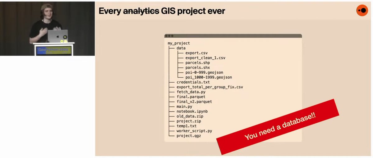
The recording of the talk on DuckDB's spatial library, presented by its author <a href="/maxxen/">katrina L bear</a> at <a href="/GeoPythonConf/">GeoPythonConf</a> 2024 is now available.

DuckDB Spatial: Supercharged Geospatial SQL
youtube.com/watch?v=hoyQnP…
SpatioTemporal Asset Catalog (@stacspec) 's Twitter Profile Photo

Hey there, data world! 👋🏽 I'm STAC 1.1.0-beta.1, here to ease your #geospatial workflow. Packed with community-driven improvements, I'm the first major update in three years. Check out the new version and give feedback before a final 1.1.0 release cloudnativegeo.org/blog/2024/08/s…

Hey there, data world! 👋🏽 I'm STAC 1.1.0-beta.1, here to ease your #geospatial workflow. Packed with community-driven improvements, I'm the first major update in three years. Check out the new version and give feedback before a final 1.1.0 release cloudnativegeo.org/blog/2024/08/s…
Kyle Barron @kylebarron@mapstodon.space (@kylebarron2) 's Twitter Profile Photo

Releasing arro3: a new Python implementation of ApacheArrow, built on the Rust Language Arrow crate. - much lighter than pyarrow - interoperable with Arrow libs like pyarrow, polars - streaming IO for Parquet, CSV, JSON, IPC - pyodide support - type hinting github.com/kylebarron/arr…

Cloud-Native Geospatial Foundation (@cloudnativegeo) 's Twitter Profile Photo

Introducing STAC GeoParquet: A specification and library for storing and serving SpatioTemporal Asset Catalog metadata as GeoParquet, which makes it easier to store, transmit & analyze large collections of STAC items. ✍️🏻Tom Augspurger Kyle Barron @[email protected] Chris Holmes 🔗cloudnativegeo.org/blog/2024/08/i…

Introducing STAC GeoParquet: A specification and library for storing and serving <a href="/STACspec/">SpatioTemporal Asset Catalog</a> metadata as <a href="/GeoParquet/">GeoParquet</a>, which makes it easier to store, transmit &amp; analyze large collections of STAC items. 
✍️🏻<a href="/TomAugspurger/">Tom Augspurger</a> <a href="/kylebarron2/">Kyle Barron @kylebarron@mapstodon.space</a> <a href="/opencholmes/">Chris Holmes</a> 
🔗cloudnativegeo.org/blog/2024/08/i…