NOAA Satellites - Public Affairs(@NOAASatellitePA) 's Twitter Profileg
NOAA Satellites - Public Affairs

@NOAASatellitePA

@NOAASatellitePA is managed by public affairs officers John Leslie & John Bateman. @NOAASatellites are the backbone of @NOAA's life-saving weather forecasts.

ID:2460145735

linkhttp://www.nesdis.noaa.gov calendar_today23-04-2014 19:27:31

4,8K Tweets

33,1K Followers

4,7K Following

NOAA Satellites(@NOAASatellites) 's Twitter Profile Photo

From more than 22,000 miles up, is watching Tropical Storm as the sun rises over the Atlantic this morning. A Tropical Storm Watch has been issued for the northern Leeward Islands.

account_circle
NOAA Satellites - Public Affairs(@NOAASatellitePA) 's Twitter Profile Photo

SATELLITE SPOTLIGHT: NOAA's ๐Ÿ›ฐ๏ธ caught the and heat signature from the in Northern California yesterday. The , which is currently California's largest active fire, has burned more than 58,000 acres and forced thousands to evacuate.

account_circle
NOAA Satellites - Public Affairs(@NOAASatellitePA) 's Twitter Profile Photo

TROPICAL UPDATE: Tropical Depression #7 has formed in the Atlantic Ocean and NOAA's ๐Ÿ›ฐ๏ธ is keeping a close eye on it. It's forecast to strengthen into Fiona and continue moving westward through the Leeward Islands. Get the latest: hurricanes.gov

account_circle
NOAA Satellites - Public Affairs(@NOAASatellitePA) 's Twitter Profile Photo

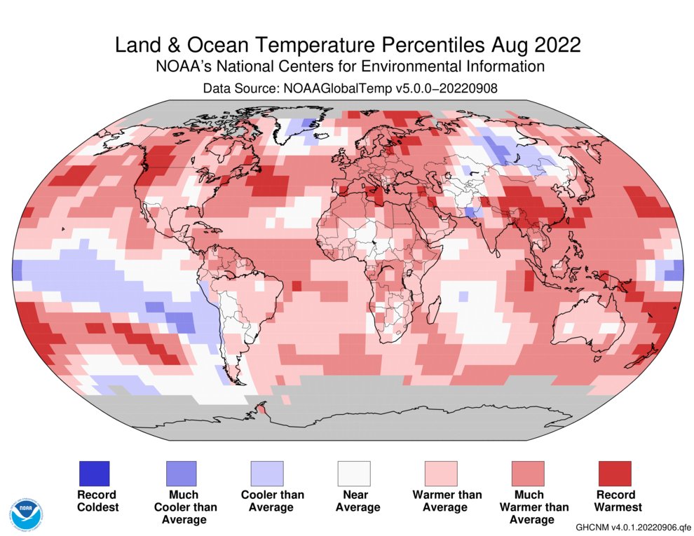
.NOAA: August 2022 was the world's sixth-hottest August on record and capped off the Northern Hemisphere's second-hottest summer. Antarctic sea ice coverage was at a record low for a third consecutive month. bit.ly/3RXLtDo

.@NOAA: August 2022 was the world's sixth-hottest August on record and capped off the Northern Hemisphere's second-hottest summer. Antarctic sea ice coverage was at a record low for a third consecutive month. bit.ly/3RXLtDo #climate #StateofClimate
account_circle
NOAA Satellites - Public Affairs(@NOAASatellitePA) 's Twitter Profile Photo

The media are invited as NOAA hosts its monthly call on Thursday, September 15, at 11 am ET. Experts will discuss the U.S. and global climate from August 2022 and provide temperature and precipitation outlooks for the U.S. through December. bit.ly/3xktNda

The media are invited as @NOAA hosts its monthly #climate call on Thursday, September 15, at 11 am ET. Experts will discuss the U.S. and global climate from August 2022 and provide temperature and precipitation outlooks for the U.S. through December. bit.ly/3xktNda
account_circle
NOAA Satellites - Public Affairs(@NOAASatellitePA) 's Twitter Profile Photo

TROPICAL UPDATE: NOAA's ๐Ÿ›ฐ๏ธ is keeping an eye on Kay in the eastern Pacific today. High winds and heavy rain will be likely across parts of So. Cal. and the Southwest. Warnings and cover parts of the region. hurricanes.gov

account_circle
NOAA Satellites - Public Affairs(@NOAASatellitePA) 's Twitter Profile Photo

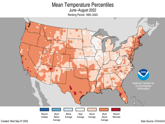
.NOAA: The U.S. just sweltered through its 3rd-hottest summer in 128 years. August 2022 was also quite warm and marked by historic flash flooding events. More: bit.ly/3RMTMSr

.@NOAA: The U.S. just sweltered through its 3rd-hottest summer in 128 years. August 2022 was also quite warm and marked by historic flash flooding events. #climate #StateofClimate More: bit.ly/3RMTMSr
account_circle
NOAA Satellites - Public Affairs(@NOAASatellitePA) 's Twitter Profile Photo

SATELLITE SPOTLIGHT: NOAA's GOES17๐Ÿ›ฐ๏ธ is tracking drifting across much of the western and central U.S. today. Emanating from numerous across the West, the smoke has prompted some Alerts and has brought hazy skies as far away as Iowa.

account_circle
NOAA Satellites - Public Affairs(@NOAASatellitePA) 's Twitter Profile Photo

TROPICAL UPDATE: NOAA's ๐Ÿ›ฐ๏ธ is closely watching in this 0.5-km resolution visible imagery this afternoon. At the last update, had sustained winds of 105 mph and a is in effect for Bermuda. Latest: hurricanes.gov

account_circle
NOAA Satellites(@NOAASatellites) 's Twitter Profile Photo

This Day Night Band imagery from the NOAA/NASA satellite shows just off the coast of Baja California, Mexico earlier this morning. A hurricane warning is in effect for the west-central portion of the peninsula.

Latest: hurricanes.gov

This Day Night Band imagery from the NOAA/NASA #SuomiNPP satellite shows #HurricaneKay just off the coast of Baja California, Mexico earlier this morning. A hurricane warning is in effect for the west-central portion of the peninsula. Latest: hurricanes.gov
account_circle
NOAA Satellites(@NOAASatellites) 's Twitter Profile Photo

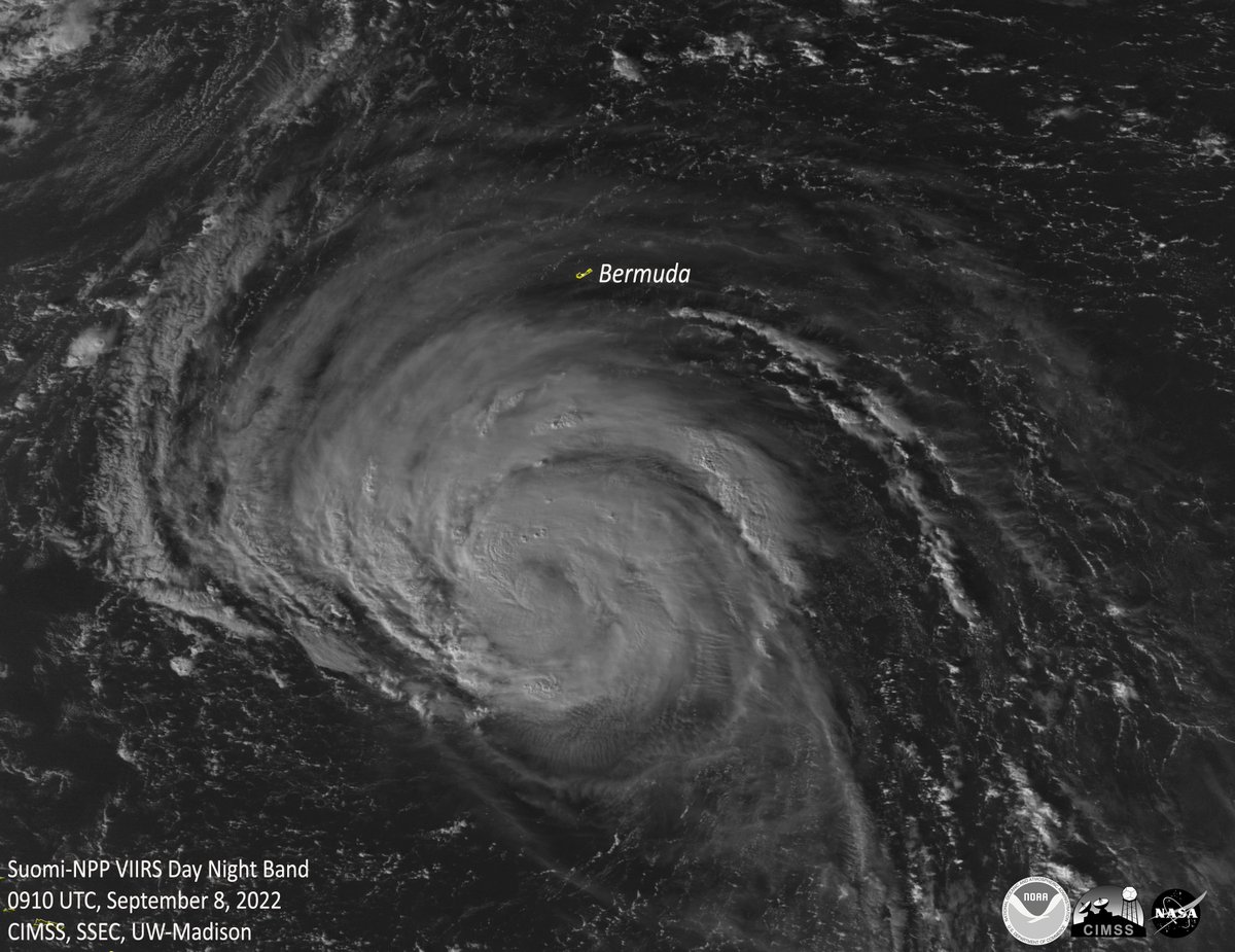
As the polar-orbiting NOAA/NASA ๐Ÿ›ฐ๏ธ passed over the Atlantic earlier this morning, it captured imagery of near Bermuda. Damaging winds and dangerous surf conditions are expected to affect the island today through tomorrow.

Latest: hurricanes.gov

As the polar-orbiting NOAA/NASA #SuomiNPP ๐Ÿ›ฐ๏ธ passed over the Atlantic earlier this morning, it captured imagery of #HurricaneEarl near Bermuda. Damaging winds and dangerous surf conditions are expected to affect the island today through tomorrow. Latest: hurricanes.gov
account_circle
NOAA Satellites(@NOAASatellites) 's Twitter Profile Photo

As the sun rises, is monitoring Kay off Mexico in the Eastern Pacific. Kay, a Category 2 storm, has strengthened slightly, with max sustained winds of 105 mph.

Watches and Warnings are in effect for Baja California.

Latest: hurricanes.gov

account_circle
NOAA Satellites - Public Affairs(@NOAASatellitePA) 's Twitter Profile Photo

SATELLITE SPOTLIGHT: NOAA's was keeping an eye on the from numerous burning across the western U.S. yesterday. Some of the larger fires burning across the region include the & in Oregon and the in Idaho.

account_circle
NOAA Satellites(@NOAASatellites) 's Twitter Profile Photo

is keeping close watch over the first of the 2022 Atlantic Season. As of 11am EDT, has winds of 75mph making it a Category 1 on the Saffir-Simpson Scale.

Currently, there are no coastal watches/warnings in effect.

Latest: hurricanes.gov

account_circle
NOAA Satellites - Public Affairs(@NOAASatellitePA) 's Twitter Profile Photo

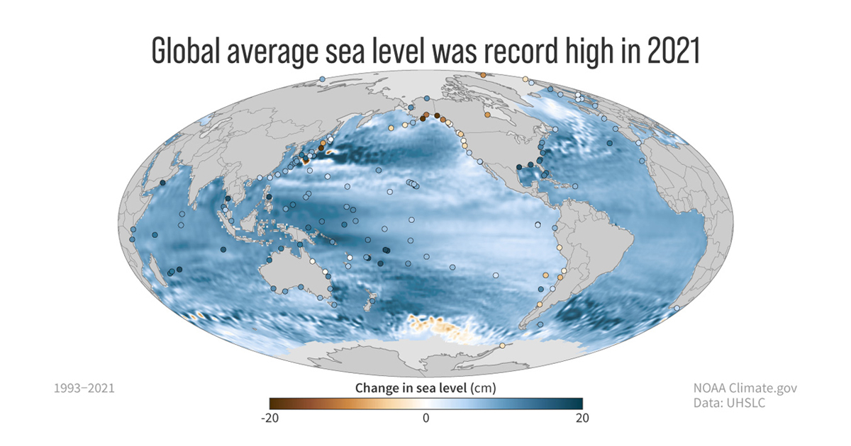
NEW: The 2021 State of the Climate international report from American Meteorological Society, and led by NOAA NCEI scientists, was released today. Greenhouse gases, global sea levels and ocean heat content all reached record highs last year. bit.ly/3AZTwK8

NEW: The 2021 State of the Climate international report from @ametsoc, and led by @NOAANCEI scientists, was released today. Greenhouse gases, global sea levels and ocean heat content all reached record highs last year. bit.ly/3AZTwK8 #BulletinAMS #StateOfClimate2021
account_circle
NOAA Satellites(@NOAASatellites) 's Twitter Profile Photo

Imagery of over the Philippine Sea today via Japan's ๐Ÿ›ฐ๏ธshows tightly wrapping bands of deep convection around a symmetric eye. With winds at 145 mph, it is the equivalent of a Category 4 Atlantic hurricane.

Latest: metoc.navy.mil/jtwc/jtwc.html
account_circle