Gemma Plumb(@plumb_pud) 's Twitter Profileg
Gemma Plumb

@plumb_pud

Weather Forecaster. Love weather facts, nature, exploring and adventures. Boobette for the amazing CoppaFeel. Thoughts my own. Host of @4loveofweather podcast

ID:313590140

linkhttps://justgiving.com/page/gemma-plumb-bowelcancerukhike2023 calendar_today08-06-2011 22:09:26

7,1K Tweets

725 Followers

1,5K Following

National Hurricane Center(@NHC_Atlantic) 's Twitter Profile Photo

8 am Friday update: NHC is monitoring an area of disturbed weather over the eastern Caribbean Sea. Conductions appear conducive for development and a tropical depression is likely to form this weekend or early next week. Follow the latest at hurricanes.gov

8 am Friday update: NHC is monitoring an area of disturbed weather over the eastern Caribbean Sea. Conductions appear conducive for development and a tropical depression is likely to form this weekend or early next week. Follow the latest at hurricanes.gov
account_circle
CoppaFeel!(@CoppaFeelPeople) 's Twitter Profile Photo

In case you need a reminder, here are some pretty good reasons to check your chest. We recommend doing it once a month, but everyone is different, so find a time/rhythm that works for you 😘

In case you need a reminder, here are some pretty good reasons to check your chest. We recommend doing it once a month, but everyone is different, so find a time/rhythm that works for you 😘 #BreastCancerAwarenessMonth
account_circle
UW-Madison CIMSS(@UWCIMSS) 's Twitter Profile Photo

Tropical Storm update via Himawari-8 IR imagery. A sprawling system with intense core convection impacting the Philippines. re.ssec.wisc.edu/s/Y2owpv

account_circle
Gemma Plumb(@plumb_pud) 's Twitter Profile Photo

Much of Europe will continue to see temperatures well above average this weekend and into the start of next week.

For some temperatures will be around 10-15C above average 🌡️

account_circle
Drought Center(@DroughtCenter) 's Twitter Profile Photo

U.S. Drought Monitor 10-27-2022:

The proportion of the U.S. in increased again to 52.7%, the highest it’s been since 2012.

The population affected also increased significantly to over 146 million people.

NIDIS Drought.gov NOAA NCEI USDA Climate Hubs Farm Service Agency Farmers.gov

U.S. Drought Monitor 10-27-2022: The proportion of the U.S. in #drought increased again to 52.7%, the highest it’s been since 2012. The population affected also increased significantly to over 146 million people. @DroughtGov @NOAANCEI @USDAClimateHubs @usdafsa @FarmersGov
account_circle
NASA(@NASA) 's Twitter Profile Photo

High above storm clouds, a crimson flash appears. It’s a sprite—one of the least-understood electrical phenomena in Earth’s upper atmosphere. You and your camera could add to a ground-breaking discovery. NASA Citizen Science and join the Spritacular project: go.nasa.gov/3W88nuA


High above storm clouds, a crimson flash appears. It’s a sprite—one of the least-understood electrical phenomena in Earth’s upper atmosphere. You and your camera could add to a ground-breaking discovery. @DoNASAScience and join the Spritacular project: go.nasa.gov/3W88nuA
account_circle
NHC_TAFB(@NHC_TAFB) 's Twitter Profile Photo

2pm EDT 10/26: A deep layered trough is interacting with a tropical wave near 65W. Heavy rainfall may result in localized flooding in parts of the eastern Caribbean Islands through at least Thu. Refer to NWS San Juan for details on Puerto Rico and the US Virgin Islands.

account_circle
NASA Earth (but haaaunted 👻)(@NASAEarth) 's Twitter Profile Photo

The ozone hole is continuing to shrink, @nasa and @noaa announced today.

The ozone hole reached an average area of 8.9 million square miles between Sept. 7 and Oct. 13, 2022 – slightly smaller than last year and continuing an overall shrinking trend. go.nasa.gov/3zkcoCp

The ozone hole is continuing to shrink, @nasa and @noaa announced today. The ozone hole reached an average area of 8.9 million square miles between Sept. 7 and Oct. 13, 2022 – slightly smaller than last year and continuing an overall shrinking trend. go.nasa.gov/3zkcoCp
account_circle
World Meteorological Organization(@WMO) 's Twitter Profile Photo

Greenhouse gas concentrations have again hit record highs

CO2 levels surged in 2021 to nearly 150% of pre-industrial era

Methane had biggest jump on record

Continued ⬆️ in 2022: WMO bulletin

UN Environment Programme releases today.


bit.ly/GreenhouseGasB…

Greenhouse gas concentrations have again hit record highs CO2 levels surged in 2021 to nearly 150% of pre-industrial era Methane had biggest jump on record Continued ⬆️ in 2022: WMO bulletin @UNEP releases #EmissionsGap today. #StateofClimate #COP27 bit.ly/GreenhouseGasB…
account_circle
Met Office(@metoffice) 's Twitter Profile Photo

Did you see any yesterday?

⚡ Around 40,000 lightning strikes occurred around the UK on Sunday, quite unusual for late October

On average, the UK gets around 200,000-300,000 lightning strikes a year

📷 Share any videos you took below using 👇

account_circle
Ben Domensino(@Ben_Domensino) 's Twitter Profile Photo

- is now having its wettest October in 159 years of records. The city's running monthly total reached 286.8 mm at 10:40am today, surpassing its previous October record of 285 mm from 1987. This extends Sydney's record-breaking annual total to 2387.6 mm.

#BREAKING - #Sydney is now having its wettest October in 159 years of records. The city's running monthly total reached 286.8 mm at 10:40am today, surpassing its previous October record of 285 mm from 1987. This extends Sydney's record-breaking annual total to 2387.6 mm.
account_circle
National Hurricane Center(@NHC_Atlantic) 's Twitter Profile Photo

The low pressure system near Bermuda is likely to become a tropical depression later today or tonight. Periods of locally heavy rainfall and gusty winds are expected over Bermuda. For more information, visit nhc.noaa.gov/gtwo.php?basin…

The low pressure system near Bermuda is likely to become a tropical depression later today or tonight. Periods of locally heavy rainfall and gusty winds are expected over Bermuda. For more information, visit nhc.noaa.gov/gtwo.php?basin…
account_circle
NHC Eastern Pacific(@NHC_Pacific) 's Twitter Profile Photo

5:20 AM MDT Sunday Update: Roslyn makes landfall in west-central Mexico near Santa Cruz in northern Nayarit. The maximum sustained winds are estimated to be 120 mph (195 km/h).

5:20 AM MDT Sunday Update: Roslyn makes landfall in west-central Mexico near Santa Cruz in northern Nayarit. The maximum sustained winds are estimated to be 120 mph (195 km/h).
account_circle
Gemma Plumb(@plumb_pud) 's Twitter Profile Photo

A deep depression over the Bay of Bengal is expected to strengthen into a cyclonic storm and could become a severe cyclonic storm for a time.

The cyclonic storm is currently forecast to make landfall in Bangladesh.

account_circle
NHC Eastern Pacific(@NHC_Pacific) 's Twitter Profile Photo

Here are the 10 PM MDT 10/22 Key Messages for Major Hurricane , expected to make landfall along the west-central coast of Mexico Sunday morning.

Here are the 10 PM MDT 10/22 Key Messages for Major Hurricane #Roslyn, expected to make landfall along the west-central coast of Mexico Sunday morning.
account_circle
NASA Earth (but haaaunted 👻)(@NASAEarth) 's Twitter Profile Photo

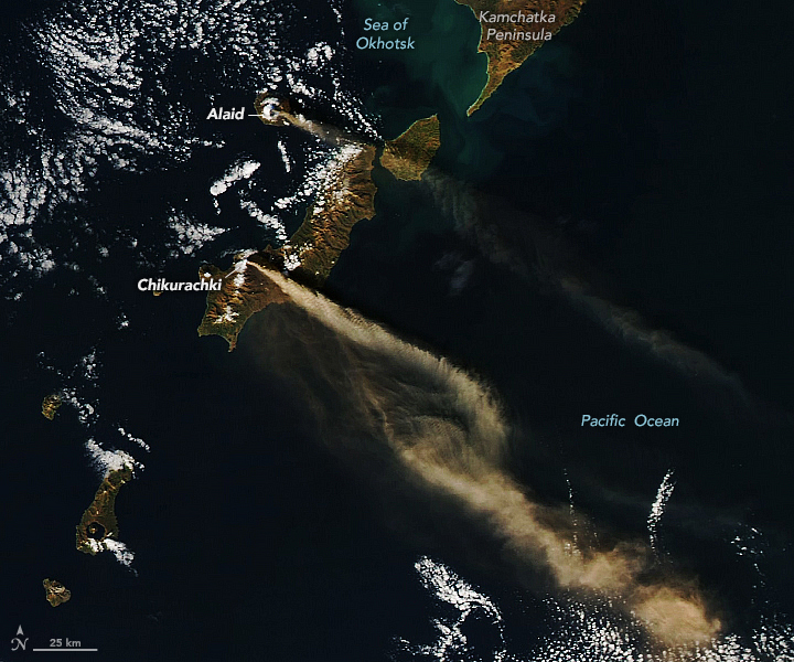
Two volcanoes in the Kuril Islands – between Japan and the Kamchatka Peninsula – erupted this month, simultaneously sending plumes of ash over the Pacific Ocean.

NASA’s Aqua satellite captured this image of the plumes on October 16, 2022. 🌋 🌋 go.nasa.gov/3MQ9ZF2

Two volcanoes in the Kuril Islands – between Japan and the Kamchatka Peninsula – erupted this month, simultaneously sending plumes of ash over the Pacific Ocean. NASA’s Aqua satellite captured this image of the plumes on October 16, 2022. 🌋 🌋 go.nasa.gov/3MQ9ZF2
account_circle
NHC Eastern Pacific(@NHC_Pacific) 's Twitter Profile Photo

Hurricane Advisory 12: Air Force Reserve Hurricane Hunter Aircraft Confirms That Roslyn Is a Category 4 Hurricane. Forecast to Reach the Coast of West-Central Mexico On Sunday. hurricanes.gov

account_circle