National Weather Service(@NWS) 's Twitter Profileg
National Weather Service

@NWS

Official Twitter account for @NOAA's National Weather Service.
A list of official NWS accounts can be found at https://t.co/x5itrXGTJT

ID:454313925

linkhttp://weather.gov calendar_today03-01-2012 21:24:25

41,4K Tweets

3,1M Followers

328 Following

Follow People
National Weather Service(@NWS) 's Twitter Profile Photo

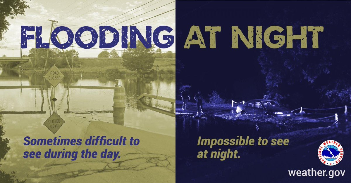
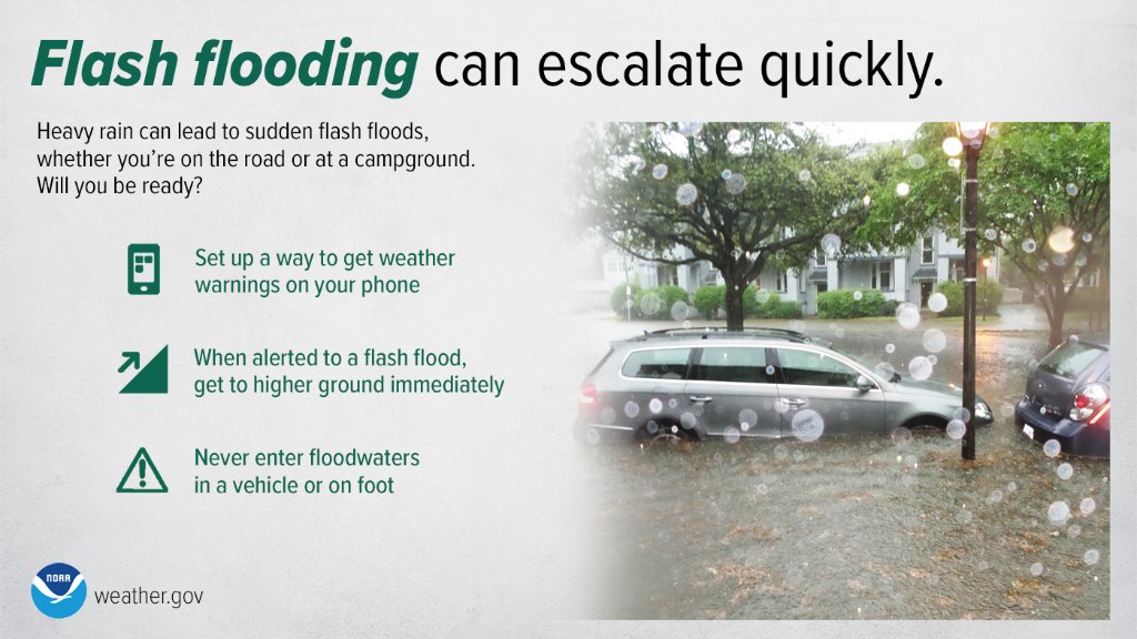
Will you be ready for sudden flash floods? Stay by enabling weather alerts on your phone. If flooding occurs while you’re outdoors, immediately get to higher ground, and NEVER enter flood waters in a vehicle or on foot. weather.gov/safety/flood

Will you be ready for sudden flash floods? Stay #WeatherReady by enabling weather alerts on your phone. If flooding occurs while you’re outdoors, immediately get to higher ground, and NEVER enter flood waters in a vehicle or on foot. weather.gov/safety/flood #WeatherReady
account_circle
NWS Tallahassee(@NWSTallahassee) 's Twitter Profile Photo

4/10/24 PM 🌧️⚠️

Flood Watch remains in effect for most of the Tri-State area until Thu afternoon. Heavy rain & flooding have been observed this evening for parts of the FL Panhandle into SE AL/SW GA. Additional rain is expected. Floods are especially dangerous at night!

4/10/24 PM 🌧️⚠️ Flood Watch remains in effect for most of the Tri-State area until Thu afternoon. Heavy rain & flooding have been observed this evening for parts of the FL Panhandle into SE AL/SW GA. Additional rain is expected. Floods are especially dangerous at night!
account_circle
NWS Tallahassee(@NWSTallahassee) 's Twitter Profile Photo

4/10/24 6:30 PM ET📡 Update:

A line of strong to severe thunderstorms is currently moving through the Florida Panhandle, and is expected to continue moving eastward over the next few hours. Primary hazards are: tornadoes and strong damaging wind gusts. ⛈️

account_circle
NWS GSP(@NWSGSP) 's Twitter Profile Photo

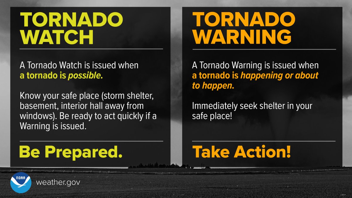
A Severe Thunderstorm/Tornado WATCH means Be Prepared.
A Severe Thunderstorm/Tornado WARNING means Take Action!
weather.gov/safety/thunder…
weather.gov/safety/tornado…

A Severe Thunderstorm/Tornado WATCH means Be Prepared. A Severe Thunderstorm/Tornado WARNING means Take Action! weather.gov/safety/thunder… weather.gov/safety/tornado… #scwx #ncwx #gawx #WeatherReady
account_circle
National Weather Service(@NWS) 's Twitter Profile Photo

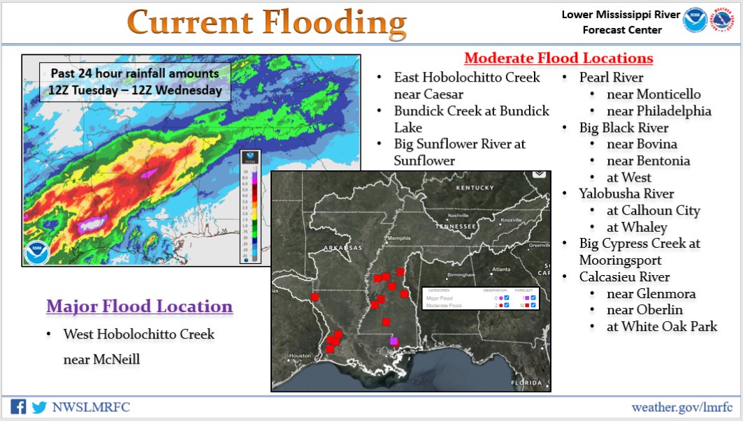
Heavy rainfall has led to moderate-to-major flooding on creeks and rivers in the Lower Misssissippi Basin this afternoon.

account_circle
NWS New Orleans(@NWSNewOrleans) 's Twitter Profile Photo

1220PM: New Orleans metro areas… DO NOT DRIVE right now! A FF Emergency is in effect for the city and there is more rain on the way from the Southwest! Numerous roads across the metro are flooded/impassable. Again, please do not drive if at all possible right now.

account_circle
National Weather Service(@NWS) 's Twitter Profile Photo

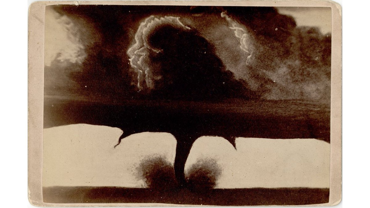
Imagine setting up your camera on a tripod to take this photo… in 1884! This is one of the earliest photos of a tornado, taken by F.N. Robinson in the Dakota Territory (now South Dakota).

Learn more at: noaa.gov/heritage/stori…

Imagine setting up your camera on a tripod to take this photo… in 1884! This is one of the earliest photos of a tornado, taken by F.N. Robinson in the Dakota Territory (now South Dakota). Learn more at: noaa.gov/heritage/stori… #tornado #cyclone #history #WeatherHistory
account_circle
National Weather Service(@NWS) 's Twitter Profile Photo

Significant Severe Weather and Flash Flood risks are in place across the Gulf Coast today. Numerous warnings are already in effect as well as several Flash Flood Emergencies. Have multiple ways to get warnings and know your safe place if warnings are issued where you are.

Significant Severe Weather and Flash Flood risks are in place across the Gulf Coast today. Numerous warnings are already in effect as well as several Flash Flood Emergencies. Have multiple ways to get warnings and know your safe place if warnings are issued where you are.
account_circle
National Weather Service(@NWS) 's Twitter Profile Photo

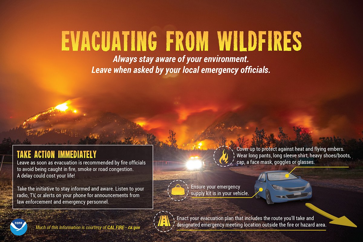
If wildfires are threatening your area, stay informed of evacuation orders. Leave immediately when asked to avoid being caught in fire, smoke, or road congestion. Have an emergency supply kit in your vehicle and know your evacuation route. weather.gov/safety/wildfire

If wildfires are threatening your area, stay informed of evacuation orders. Leave immediately when asked to avoid being caught in fire, smoke, or road congestion. Have an emergency supply kit in your vehicle and know your evacuation route. weather.gov/safety/wildfire
account_circle
NWS Corpus Christi(@NWSCorpus) 's Twitter Profile Photo

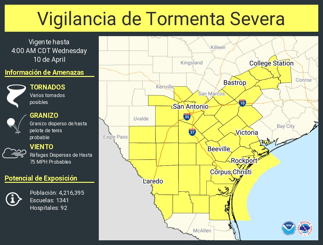
All of South Texas is under a Severe Thunderstorm Watch through 4 AM Wed. Large hail & strong damaging wind gusts are the primary threats, followed by isolated tornadoes. This is a night event, have a plan, and make sure you have multiple ways to receive warnings!

account_circle
NWS Anchorage(@NWSAnchorage) 's Twitter Profile Photo

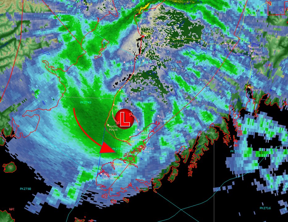
⚠Heads up for our friends down in Homer and Soldotna!
Moderate to heavy snowfall and reduced visibilities can be expected the next 2-3 hours for the Southern Kenai Peninsula. 🌨

⚠Heads up for our friends down in Homer and Soldotna! Moderate to heavy snowfall and reduced visibilities can be expected the next 2-3 hours for the Southern Kenai Peninsula. 🌨
account_circle
NWS Sioux Falls(@NWSSiouxFalls) 's Twitter Profile Photo

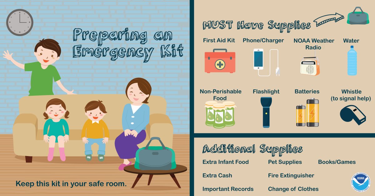
Do you have a severe weather safety kit?

If not, it’s important to gather these items ahead of time and put them in a place you can get to quickly should severe weather threaten you.

Do you have a severe weather safety kit? If not, it’s important to gather these items ahead of time and put them in a place you can get to quickly should severe weather threaten you.
account_circle
NHC_TAFB(@NHC_TAFB) 's Twitter Profile Photo

A strong cold is forecast to bring conditions to the northeastern Gulf of Mexico, and Atlantic waters east of northeast Florida. Marine interests in these areas need to monitor this developing situation and plan accordingly.

A strong cold #front is forecast to bring #hazardous #marine conditions to the northeastern Gulf of Mexico, and Atlantic waters east of northeast Florida. Marine interests in these areas need to monitor this developing situation and plan accordingly.
account_circle
NWS Storm Prediction Center(@NWSSPC) 's Twitter Profile Photo

4/9: Severe Thunderstorm Watch #96 is in effect for portions of central Texas until 11pm CDT. Primary concerns are large hail (some 2 inches in diameter) and damaging winds to 70 mph, though a tornado or two cannot be ruled out. spc.noaa.gov

4/9: Severe Thunderstorm Watch #96 is in effect for portions of central Texas until 11pm CDT. Primary concerns are large hail (some 2 inches in diameter) and damaging winds to 70 mph, though a tornado or two cannot be ruled out. spc.noaa.gov #TXwx
account_circle
National Weather Service(@NWS) 's Twitter Profile Photo

Severe thunderstorms are expected to produce several tornadoes, significant large hail, and damaging winds across much of Texas towards the Lower Mississippi Valley through Wednesday morning and across the Gulf Coast States on Wednesday.

Ensure you know where you would take…

Severe thunderstorms are expected to produce several tornadoes, significant large hail, and damaging winds across much of Texas towards the Lower Mississippi Valley through Wednesday morning and across the Gulf Coast States on Wednesday. Ensure you know where you would take…
account_circle